CONVECTIVE FORECAST
VALID 06Z TUE 27/04 - 06Z WED 28/04 2004
ISSUED: 26/04 21:20Z
FORECASTER: HAKLANDER
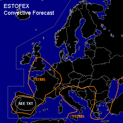
General thunderstorms are forecast across SRN parts of the British Isles, most of the Iberian Peninsula, France and the Benelux countries, Italy, the WRN Balkan, Turkey, and ERN parts of the Black Sea.
SYNOPSIS
An upper trough across the Irish Sea digs southward and cuts off a closed low across the Bay of Biskay. On the southern flank of this trough, an intensifying jet streak is forecast across Northern Spain at the end of the forecast period. Below the southerly upper flow on the eastern flank of the trough, a weak surface low across the Iberian Peninsula and France induces low-level convergence. Farther east, a weak upper ridge across Sardinia extends toward Germany. Across Southern Greece an ULL migrates to the Black Sea.
DISCUSSION
...Iberian Peninsula...
Whereas solar insolation should increase theta-e in the boundary layer to about the same values as Monday, cold air advection is forecast right above the boundary layer, as the upper low approaches. According to GFS12Z, 500-1000 J/kg MUCAPE should build across large parts of the Iberian Peninsula on Tuesday afternoon. However, Mondays GFS12Z run overestimated the +6h forecast 2m dew-point temperatures across much of W-Europe by 3-5K. We therefore expect that forecast MUCAPEs for Tuesday will be too high because of this positive surface moisture bias. Nevertheless, CIN should become low enough for more widespread thunderstorm activity than was observed on Monday. The 20+ m/s deep-layer shear that is associated with the approaching jetstreak from the north should remain north of the area with significant CAPE, reducing the risk for severe storms. Although supercells are considered unlikely due to unfavorable wind shear, WBZ heights should be at 2-2.5 km AGL. Given more than marginal CAPE, large hail cannot be ruled out within stronger cells. A deep, dry layer is not forecast at mid-levels, reducing convective wind gusts owing to evaporational cooling.
...France...
Some thunderstorms of the single or multicell type are expected to form as a result of diurnal boundary layer heating, cooling mid-levels from the west and boundary layer convergence. The left-exit region of the aforementioned jetstreak should be situated across Western France during Tuesday afternoon and evening, inducing upward motion at mid-levels and hence, further destabilization.
#