CONVECTIVE FORECAST
VALID 06Z FRI 23/04 - 06Z SAT 24/04 2004
ISSUED: 22/04 20:58Z
FORECASTER: GATZEN
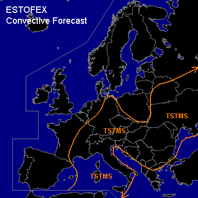
General thunderstorms are forecast across western Mediterranean
General thunderstorms are forecast across eastern Europe
General thunderstorms are forecast across southern and southeastern Central Europe
SYNOPSIS
Several short-wave vort-maxima are present over Europe, where diverging westerly flow forms a weak ridge over Central Europe. One vort-max will cross northern Central Europe, another will move southeastward over eastern Europe. Over the Mediterranean ... vort-maxima are present over the western and eastern portions. During the forecast period ... European upper ridge will weaken as upper long-wave trough starts to build over Europe. To the west ... upper short-wave ridge is forecast to amplify over western Europe.
DISCUSSION
...Western Mediterranean
...
Intense cut-off digging slowly ESE-ward reaching the border of northern Africa on Friday. To the south of this feature ... relatively strong westerly jet streak is expected over northern Algeria/Tunisia. DCVA is forecast to the southeast of the cut-off. At lower levels ... CAA is forecast in the range of the trough, while weak WAA is expected to the south and to the east. Resulting synoptic UVM will be present over the extremely southern forecast region. Warm airmass east of the cold front is characterized by mid-level steep lapse rates and a rather cold boundary layer. However ... it seems that instability has increased significantly and thunderstorms have formed over the western Mediterranean east of the cold front. On Friday ... surface low is expected over northern Africa, and instable airmass should remain over the west-central Mediterranean. Showers and thunderstorms are expected. Rather strong low-level wind shear will be present, while deep layer wind shear will increase to the south. Multicells may form and produce strong wind gusts. There is also a slight chance that rotating storms will form that produce marginally severe hail or a brief tornado.
...Eastern Europe
...
Small cut-off low will move SE-ward reaching the western Black Sea on Friday evening. To the southwest ... warm airmass characterized by low-level inverted-V profiles is advected eastward. However ... it seems that this airmass will not be affected by the upper cut-off. In the range of the cut-off ... low-level airmass is rather cold and relatively moist. On Friday ... destabilization is expected, and thunderstorms should form. Strong deep layer wind shear will be present and thunderstorms should likely organize into multicells or short bow echoes. Severe thunderstorms may form, producing strong wind gusts and marginally severe hail.
...Southern and southeastern Central Europe
...
Unstable airmass characterized by inverted-V-profiles will be present. During the day ... thunderstorms are expected and may cluster when cold pools form. Vertical wind shear will be rather weak increasing over eastern Germany in the range of the short-wave trough. Severe wind gusts should be the main severe threat if storms will organize.
#