CONVECTIVE FORECAST
VALID 06Z THU 22/04 - 06Z FRI 23/04 2004
ISSUED: 21/04 21:19Z
FORECASTER: GROENEMEIJER
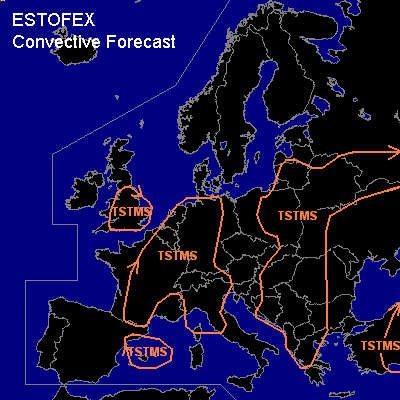
General thunderstorms are forecast across southern Great Britain.
General thunderstorms are forecast across much of west-central Europe
General thunderstorms are forecast across parts of the western Mediterranean
General thunderstorms are forecast across parts of Greece, the central and north-central Balkans, Slovakia, the northeastern Ukraine, the southern Baltic States, much of Belarus and the central Russian plateau.
General thunderstorms are forecast across parts of Turkey
SYNOPSIS
Thursday at 06Z... a mid/upper-level cold core low pressure centre over Lithuania
is expected to be moving southsoutheastward reaching the northern Ukraine Friday morning. On its western flank, a weak cold front is expected to surge southward
over central and eastern Poland. The air mass south of the front and the mid/upper low may become sufficiently unstable to allow for a few thunderstorms near the mid/upper low and perhaps along the cold front. To the east of the low, a few storms could occur as well over Belarus and western Russia.
Further south...
over the central Danube valley and the Hungarian plains the air-mass will likely be sufficiently destabilised by solar heating for thunderstorm formation
to occur.
Upstream...
a intense trough located over central Spain Thursday at 06 is expected to evolve into a cut-off low over the western Meditarranean. A few storms are possible
near the low's centre where the steepest lapse rates occur.
DISCUSSION
...Western continental Europe...
...
A stationary oriented frontal zone is located from southwestern France to the
western Benelux countries. Models have different solutions with respect to the development of a frontal wave. Some models, e.g. AFWA MM5 (12Z, 18Z), GME 12Z do not develop this wave that should be forming over central France during Thursday morning and move northeastward according to other models including GFS 12Z and KNMI-HiRLAM 12Z. In case the wave develops strongly, a higher threat of thunderstorms will be present over central and eastern France, the Benelux countries, western and northwestern parts of Germany. In the case the wave does not develop, a more limited threat of thunder will exist near the frontal zone over eastern France, the eastern Benelux, and western Germany. Chances of convenction to become severe appears to be quite small in either case.
...Britain......
A few 100's of J/kg uncapped CAPE are expected to form over southern Britain, resulting in isolated to scattered thunderstorms. Given that wind shear is rather low chances of severe weather will be small. An isolated land/waterspout can however not be completely excluded since LCL heights will likely be quite low.
#