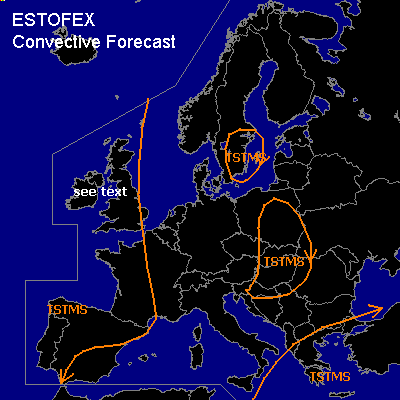

CONVECTIVE FORECAST - UPDATE
VALID 12Z WED 21/04 - 06Z THU 22/04 2004
ISSUED: 21/04 12:02Z
FORECASTER: GATZEN
General thunderstorms are forecast across eastern Mediterranean
General thunderstorms are forecast across western Europe
General thunderstorms are forecast across southern Scandinavia
General thunderstorms are forecast across eastern and southeastern Central Europe
SYNOPSIS
Omega flow pattern present over Europe ... with a ridge axis extending from western Mediterranean to southern North Sea and upper troughs over northeastern Mediterranean and northeastern Atlantic Ocean. Over southern Scandinavia ... upper short-wave trough is expected to cut off.
DISCUSSION
...Eastern Mediterranean ...
Underneath the eastern trough ... convectively mixed polar airmass is present, and showers and thunderstorms have formed. During the forecast period ... convective activity should go on. CAPE will remain quite low due to numerical model output and strong thunderstorms should be quite unlikely. However ... as deep vertical wind shear is strong ... organized convection like short bow echoes and marginally severe wind gusts are not ruled out.
...Western Europe ...
West of the ridge axis ... southwesterly flow and WAA is expected. Along a stalling front that is expected from western Iberian Peninsula to Great Britain ... instability is expected due to moisture flux convergence and diabatic heating. Aloft ... southwesterly jet streak is expected from northwestern Spain to central England in the afternoon, yielding synoptic lift especially over northwestern Great Britain. Showers and thunderstorms may form during the day. As vertical wind shear will be quite strong ... thundestorms may organize into bow echoes and multicells and severe wind gusts may occur. There is also an enhanced tornado threat due to low LCL heights and adequate low level wind shear.
...Eastern and southeastern Central Europe...
At low levels ... cold front of Scandinavian trough dissolves over eastern Central Europe, and moisture flux convergence/ diurnal heating leads to instability along and ahead of the front. Showers and thunderstorms are forming ATTM moving slowly SE-ward. Aloft ... jet streak of eastern Mediterranean trough and associated upward vertical motion field moves southward into more stable airmass. Convective activity is expected duing the next hours over the affected region and should die in the evening hours. Strong thunderstorms are not expected as vertical wind shear remains quite low.
#