CONVECTIVE FORECAST
VALID 06Z TUE 20/04 - 06Z WED 21/04 2004
ISSUED: 19/04 21:05Z
FORECASTER: HAKLANDER
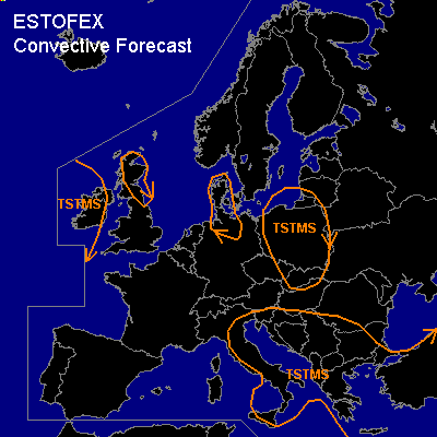
General thunderstorms are forecast across Ireland, Scotland, Denmark and N-Germany, Poland and Slovakia, much of Italy, the Adriatic Sea, the Balkan Peninsula, and Turkey.
SYNOPSIS
Across France and parts of C-Europe, a building upper ridge induces some stabilization. Farther SE, a vorticity maximum filled with relatively cold air at midlevels (ULL) slowly migrates from S-Italy to Greece. On its eastern flank, CAPE is created by theta-e advection at low levels. Meanwhile, an intensifying Atlantic longwave trough approaches W-Europe. The associated cold front should reach NW-Spain near the end of the forecast period. Most numerical models suggest delay of this frontal zone due to the formation of a baroclinic wave NW of Spain.
DISCUSSION
...Italy, the Balkan Peninsula, and Turkey...
The aforementioned ULL does have a jet streak along its south side, but the area with 20+ m/s bulk shear should not or barely overlap with the positive MUCAPE area. Furthermore, only a few hundred J/kg of MUCAPE is forecast, which does not yield a favorable environment for severe storms in the absence of high vertical wind shear.
...Poland...
About 500 J/kg MUCAPE should form across NRN parts of Poland during Tuesday in a low-shear and relatively moist environment. Therefore, the convective mode will likely be single cells and multicells. Given WBZ heights of about 2 km AGL and not too low CAPE, hail of 1-2 cm diameter, i.e. non-severe hail, seems possible within these thunderstorms. As in any low-shear and moist environment, there will be less turbulent exchange of moisture, heat and vorticity between an updraft and the surrounding air. The actual risk of spouts is difficult to quantify, so we only mention the enhanced spout probability here.
...Iberian Peninsula...
Mondays GFS12Z forecast soundings indicate significant warm air advection at midlevels on Tuesday, prohibiting the formation of CAPE despite theta-e advection at low levels. Near the end of the forecast period, the situation should destabilize from the west, at the approach of the upper trough. Current thinking is that prefrontal thunderstorms will not be triggered before Wednesdays insolation, i.e., after this forecast period.
#