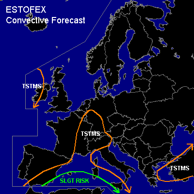

CONVECTIVE FORECAST
VALID 06Z THU 15/04 - 06Z FRI 16/04 2004
ISSUED: 14/04 19:11Z
FORECASTER: GATZEN
There is a slight risk of severe thunderstorms forecast across parts of SWern Mediterranean
General thunderstorms are forecast across SWern Mediterranean and SWern Central Europe
SYNOPSIS
Upper ridge will be present over eastern Europe at the beginning of the forecast period. Over France, cut-off low will slowly move northeastward reaching SWern Central Europe on Thursday evening. Over northwestern Africa ... strong upper trough moves eastward yielding a deep southwesterly flow over the western Mediterranean. At the end of the forecast period ... a very strong jet streak will reach the northern African border, and intense cyclogenesis is forecast over the western Mediterranean.
DISCUSSION
...SWern Central Europe
...
As upper cut-off low moves northeastward ... some DCVA is expected over SWern Central Europe. At lower levels ... warm airmass is advected northward. Latest model output suggests Theta-E in the range of 30K ahead of the trough over Germany. At the surface, some moisture will enter SWern Central Europe in the afternoon. Due to insolation, isolated showers and thunderstorms may form, especially where orography will support initiation. As vertical wind shear and CAPE are forecast to be rather weak ... severe thunderstorms are not expected. Best potential for organized convection is expected over the SWern Alpine region ... where vertical wind shear will be larger... with SEerly winds at the surface and WSWerly winds aloft. As a consequence, the chance for rotating updrafts should be slightly enhanced. Marginally severe hail and/or windgusts should be the main severe threat due to rather poor low-level moisture. Overall threat is expected to be quite weak though.
...SWern Mediterranean
...
Very strong (>100 kts @ 500 hPa) jet streak is forecast over central Algeria by Thursday, 18Z. Downstream ... SWerly flow is expected over the SWern Mediterranean east of approaching southern short-wave trough. Latest model output suggests strong WAA over the affected region, as 850 hPa Theta-E should reach more than 50K south of the warm front as indicated by latest GFS output. As a consequence, intense cyclogenesis is forecast over the western Mediterranean during the following 48 hours. Over the northwestern Mediterranean ... strong WAA should lead to intense rain north of the warm front that is expected from southern Sicily to southern Sardinia by Friday, 00Z. Some embedded thunderstorms may occur, especially when orography will lead to additional lift. In the range of the warm sector ... instability of the warm airmass is questionable during the night hours. It is not ruled out that elevated CAPE will be available ... and thunderstorms may form as the strong jet streak approaches. If thunderstorms may form and become surface-based ... very strong low-level wind shear and low LCL heights will be more than sufficient for mesocyclones and associated tornadoes. However ... chance for surface-based thunderstorms is expected to be quite low ... and risk for organized severe convection should be slightly enhanced.
To the west ... cold front of intensifying surface low will move eastward. Along this cold front ... thunderstorms may be more likely than inside the warm sector. However ... GFS model output does not show sufficient instability... leading to the assumption that widespread strong convection will not form. Along the cold front ... intense rain and embedded thunderstorms are expected. Due to the strong pressure gradient ... strong to severe wind gusts will be possible with any thunderstorm that forms due to outflow-interaction. If thunderstorms will become surface-based ... chance for severe thunderstorms will be enhanced significantly due to strong low-level vertical wind shear and low LCL heights.
West of the cold front ... convectively mixed airmass spreads eastward. As the jet streak approaches ... synoptic upward vertical motion is expected. Thunderstorms should form and move northeastward. Strong synoptic forcing and relatively strong deep layer wind shear are forecast, and thunderstorms should organize into multicells and bow echoes. There should be also a slightly enhanced threat of tornadoes along the gust fronts due to low LCL heights.
#