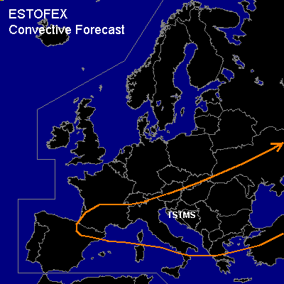

CONVECTIVE FORECAST
VALID 06Z WED 14/04 - 06Z THU 15/04 2004
ISSUED: 13/04 18:33Z
FORECASTER: GATZEN
General thunderstorms are forecast across southeastern Europe
General thunderstorms are forecast across northern Mediterranean
SYNOPSIS
Large-scale flow pattern over Europe is dominated by an upper low over southern Central Europe and northern central Mediterranean, yielding a strong westerly flow over the southern and eastern Mediterranean. Weak 500 hPa geopotential is also present over southwestern and northeastern Europe. An upper ridge is forming over northern Central Europe. During the forecast period ... upper ridge will expand into southern Central Europe as Mediterranean trough will move eastward. Over southern France ... cut off low is forecast to remain.
DISCUSSION
...Southeastern Europe
...
Thunderstorms should be likely in the range of the Mediterranean upper trough that moves eastward into southeastern Europe. At the surface ... low pressure system is forecast over northern Black Sea by Wednesday 12Z ... the cold front should have left the forecast region already. However ... models suggest a kind of "backbend"-occlusion from northern Black Sea to the northern Adriatic Sea. South of this frontal boundary ... relatively warm and moist airmass is expected. Today, some thunderstorms are forming in this airmass over southeastern Adriatic due to upslope flow. Tomorrow ... some synoptic scale lift may be present in the range of the upper trough that may support thunderstorms. Model output suggests at least weak CAPE during the afternoon due to diurnal insolation. As vertical shear will be weak, chance for severe thunderstorms will be not enhanced significantly. To the south ... deep vertical wind shear will be more sufficient for thunderstorm organization. However ... models suggest rather weak synoptic scale forcing, and thunderstorms should be not very likely.
...Northern Mediterranean
...
Upper geopotential will rise during the forecast period. However ... vorticity axis of weakening upper trough stretching from the northern Balkans to northern Iberian Peninsula will affect the northern Mediterranean on Wednesday. At low levels ... latest ascents show relatively cold airmass and neutral to slightly unstable lapse rates, and some thunderstorms have developed over northern Italy. On Wednesday... showers and thunderstorms are expected underneath the trough axis from the Pyrenees to Italy due to insolation. Cold airmass should be rather dry over France limiting the chance for thunderstorms. Severe thunderstorms are not likely as vertical wind shear will be weak.
#