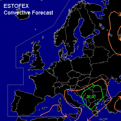

CONVECTIVE FORECAST
VALID 06Z MON 12/04 - 06Z TUE 13/04 2004
ISSUED: 11/04 21:31Z
FORECASTER: GROENEMEIJER
There is a slight risk of severe thunderstorms forecast across parts of the Balkans
General thunderstorms are forecast across parts of the western and central Mediterranean, Italy, the Adriatic, the Balkans and parts of Russia.
SYNOPSIS
A mid/upper low is located over the western Mediterranean area. A strong west-southwesterly jet is present on its southern and southeweastern flanks. An elevated mixed layer has been advected northward over southern Italy and the southern Balkans during the last few days, resulting in very steep lapse rates over this area.
DISCUSSION
...southern Balkans...
An intensifying cold front is expected from near Naples to eastern Sicily southward by Monday 06Z,
and is moving eastward to reach the western Balkan/Greek coast during early Tuesday. A few 100's of J/kg of CAPE are expected to form ahead of the front over the Balkans and the Adriatic. Ahead of the front, low-level capping is expected to weaken by WAA and DCVA relating rising motions due to an approaching trough. Consequently, it seems likely that surface-based prefrontal storms will form in the afternoon. It is not excluded that a few elevated storms are already ongoing at that time. Given that quite strong deep-layer shear (25 m/s bulk 0-6 km shear) is present, formation of a few supercells appears likely, that will be capable of producing strong winds, large hail and perhaps one or two tornadoes. The storms will likely merge into one or two linear convective systems and continue a east-northeastward motion during the evening. Overnight, the convective activity will likely persist, although the severe weather threat is expected to diminish gradually.
#