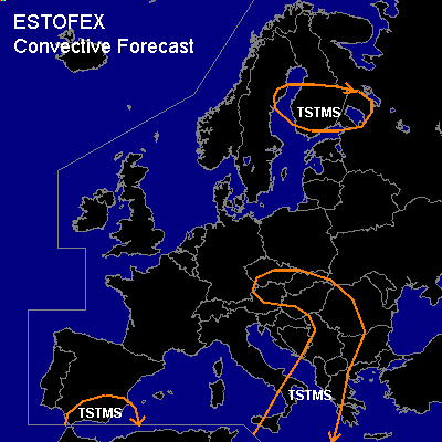

CONVECTIVE FORECAST
VALID 06Z SUN 11/04 - 06Z MON 12/04 2004
ISSUED: 11/04 01:57Z
FORECASTER: VAN DER VELDE
General thunderstorms are forecast across southeastern Spain
General thunderstorms are forecast across southeastern Italy, Balkan, Austria, Slowakia
General thunderstorms are forecast across southern Finland
SYNOPSIS
Old SW-NE oriented upper trough from Finland to Spain and surface low pressure at its east side and building high pressure over Western Europe at its west side. A cold front occlusion is moving into central Europe. In northern Europe, maritime polar convection associated with a low pressure system could be deep enough to produce some thunder.
DISCUSSION
...southeastern Italy, Balkan...
Generally marginally unstable conditions inside the surface low pressure area, where warm air/steep lapse rate advection (theta-e tongue) from the Sahara takes place. This and ascending motions over the area will have increased the instability enough by early Monday to produce thunder at wider scale. The jetstream and strongly veering wind profiles are present over the area, but during the forecast period convection is likely to be elevated. However the wind profile will be veering and increasing with height over a deep layer, so that storms may profit from it and develop strong updrafts capable of producing marginally large hail. Tornadoes are not anticipated because of the elevated nature of these storms.
...southeastern Spain...
CVA at the apex of the upper trough and steep lapse rates in the 12Z/00Z Gibraltar sounding, plus convergent near-surface flow will be supportive of thunderstorms.
...Austria/Czech Republic/Slowakia...
Surface convergence at the CF occlusion in reasonably cold air and rising motion east of the upper trough along with GFS Lifted Index < 2 and strong convective precipitaton signal may be enough for thunderstorms to develop. Although 0-6 km shear looks impressive, shear closer to the ground, within weak pressure gradient area, seems too marginal to support severe storms with this amount of instability.
#