CONVECTIVE FORECAST
VALID 06Z FRI 09/04 - 06Z SAT 10/04 2004
ISSUED: 09/04 01:57Z
FORECASTER: VAN DER VELDE
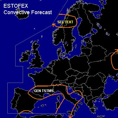
General thunderstorms are forecast across north-central Norway and Sweden
General thunderstorms are forecast across Srn France, Nrn/Cntrl Italy
SYNOPSIS
Cold upper trough will cut off and displace southward towards Southern France. At its southeast side, the jetstream and a slightly deepening surface low. The sfc front between cold polar air and subtropic air is situated over Srn Spain-Sardegna-Cntrl Italy, and the theta-e plume is advancing northward.
A vigorous sfc/upper low digs into central Scandinavia.
DISCUSSION
...north-central Norway and Sweden...
LI less than 2 or even negative behind a cold front indicate potential for deep convection, although current IR imagery does not show anything of this yet. Very strong CVA will provide a lot of lift at the coast and this is accompanied by both strong low (>15 m/s) and deep layer shear (>15-35 m/s) and LFCs below a kilometer, which may favor an isolated brief tornado. However, strong subsidence is expected due to low level CAA, which may suppress convective development.
#