CONVECTIVE FORECAST
VALID 06Z THU 08/04 - 06Z FRI 09/04 2004
ISSUED: 08/04 00:49Z
FORECASTER: VAN DER VELDE
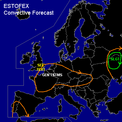
There is a slight risk of severe thunderstorms forecast across NErn Ukraine
General thunderstorms are forecast across West/Central Europe
SYNOPSIS
Upper low over central parts of Europe with cold temperatures aloft generate generally unstable conditions over much of the area. A SFC low over Eastern Europe with cold front pushing warm theta-e air eastward. WAA, CVA ahead of upper trough + CAPE coming together in a way better than the previous day. The eastward jetstream is positioned over Spain-Alps-Balkan into Ukraine, and the southward jet will increase in strength over Great Britain.
DISCUSSION
...NErn Ukraine area...
Previous GFS runs have underforecast CAPE for the previous day, where 1200 J/kg was observed instead of some 300 J/kg, and thunderstorms were quite active. For this day, the same is expected. The setup forecast for today in fact looks better, and deep layer shear will be moderate. Low level shear is forecast to be significant (>10 m/s 0-1 km shear), due to fairly strong 850 hPa height gradients. Together with LFCs of around 600 meters and abundant synoptic scale lift, widespread thunderstorms can be expected that may occasionally rotate and include an isolated tornado, and especially in case CAPE around 1000 J/kg may arise in these shear conditions, potential for large hail will be present.
...SErn England...
Jetstream gains strength over this area, while GFS (low level) instability indications are sufficient for strong low level updrafts, and seems to be well in accordance with the approach of an upper trough from the North Sea with plenty of CVA. Moderate deep/low layer shear may support rotating updrafts which may translate into an isolated tornado given also low LFCs. Small hail up to 1 cm diameter is likely.
...Iberian Peninsula ...
A theta-e plume ahead of the upper trough and sfc convergence will likely cause a few thunderstorms there. Shear conditions will be very marginal. Forecast CAPE by GFS is meager.
#