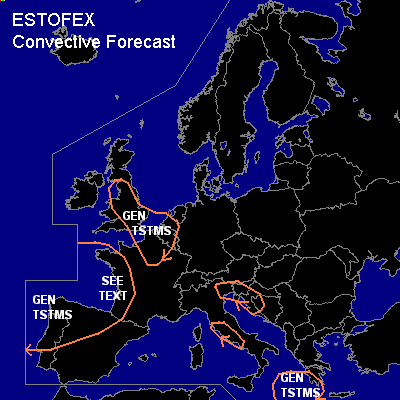

CONVECTIVE FORECAST
VALID 10Z THU 01/04 - 06Z FRI 02/04 2004
ISSUED: 01/04 10:28Z
FORECASTER: GROENEMEIJER
General thunderstorms are forecast across northwestern, western and southwestern France, northwestern Iberia, the southwestern benelux countries, northwestern France, parts of Great Britain, Italy, Slovenia, Croatia, Bosnia and Greece.
SYNOPSIS
Thursday at 12Z... an upper ridge is located over north-central Europe. Between a low pressure center 500 km northwest of Galicia and this ridge.. a warm air advection regime is in place. A cold front over the Bay of Biscay and northwestern Iberia is expected to move into central Iberia, western France and the southwestern British Isles. A jet steak is initially located from southwestern Spain to southwestern France, while moving northward. Downstream... a shortwave over the Ionean Sea is forecast to move eastward into Greece, reaching western Turkey by Friday morning 06Z. An intense trough over western Russia and the central Ukraine is expected to move eastward while a cut-off low forms over the northeastern Black Sea.
DISCUSSION
...Western and southwestern France...
The cold front is expected to move slowly into western France. Though low-level moisture availability will be higher here compared with the Spanish plateau, latent instability will probably not be present initially. However, continiuing rising motion in the left exit region of the aforementioned jet streak will likely cause destabilisation over western and southwestern France, so that eventually some latent instability will likely form near and on the cold side of the frontal zone. NWP models develop convective precipitation from the early evening onward. Negatives for severe convective development are that seems as though most of the deep layer shear will be located somewhat east of the most instability and time of day. Furthermore, low-level shear is expected to be rather limited - that could otherwise indicate a tornadic threat. Therefore we will not issue a slgt risk category at this moment.
...Spain...
The cold front is expected near a line from Santander to Sevilla at 12Z and near the Spainsh east coast Friday at 06Z. Rather stable conditions near the front are expected to preclude the occurrence of thunderstorms near this system. Behind the system, much lower mid/upper temperatures are present so that marginal latent instability is present there as is evident from the storms already ongoing off-shore. Therefore, some thunderstorms will likely occur over northwestern Spain. Wind shear will however be much lower behind the front/jet streak. This fact, together with the low instability implies the chances of severe weather are small.
...Benelux, northwestern France, parts of Britain...
Quite steep lapse rates were measured in 00Z soundings of De Bilt (06260), Wattisham (EGUW) and Nottingham (03354). Daytime heating should be sufficient for some thunderstorms to develop, considering the observed 8-11 C SFC dew points, though some places, especially in the UK may not see much heating because of the stratiform cloud cover locally in place. Up to 500 J/kg MLCAPE can be reached in places by the end of the afternoon, especially over the southwestern Benlux and extreme northwestern France. Deep-layer wind shear is and is expected to remain low. We expect a number of single-and multicells capable of producing hail below the severe limit of 2 cm.
#