CONVECTIVE FORECAST
VALID 06Z TUE 23/03 - 06Z WED 24/03 2004
ISSUED: 22/03 20:41Z
FORECASTER: HAKLANDER
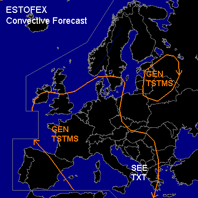
General thunderstorms are forecast across the SRN British Isles, Denmark, the Benelux countries, Germany, France, the WRN and Central Mediterranean and the WRN Balkan.
General thunderstorms are forecast across the Baltic States, Belarus and a small part of WRN Russia.
SYNOPSIS
At TUE/06Z, a broad upper trough across the Norwegian Sea and Scandinavia narrows while extending SWD across the Benelux region towards Corsica and Sardinia. On its periphery, a 50-60 m/s jet at 300 hPa meanders from Iceland across Ireland and NERN Spain towards NRN Tunesia, where it curves NEWD across Central Italy, towards Poland and Russia. During the FCST period, a separate ULL should develop across NRN Italy. The cold front that is associated with this low, should travel ESEWD across the Ionean Sea during TUE, reaching Greece early TUE evening. Meanwhile, a shortwave moves SWD from Ireland to NWRN Spain, yielding a more westerly jet from Spain to Greece at WED/06Z. At mid-levels, a 40-45 m/s jet streak at 500 hPa should migrate from NERN Spain via NRN Tunesia towards Sicily.
DISCUSSION
...SRN Italy, Ionean and Adriatic Sea, Albania, Greece...
Ahead of the aforementioned cold front, theta-e advection at low levels should yield increased latent instability. According to GFS12Z, 0-3 km shear might become 15-20 m/s in that area, but MUCAPE should remain very marginal. Because of this wind shear, severe convective wind gusts due to downward momentum transport are not ruled out. Furthermore, significant quasi-linear upward motion due to DCVA is expected along the surface cold front, enhancing and sustaining convective activity. With coastal convergence and upslope flow providing an extra source of lift, large precipitation amounts are possible, which may result in local floodings. Despite the strong vertical wind shear near the cold front, we have refrained from issuing a SLGT due to the weak thermodynamic setup.
...Remainder of the Central and WRN Europe GEN TSTMS area...
Due to the diurnal boundary layer heating, scattered deep convection should mainly initiate during the day within the polar air mass. MLCAPE should remain (well) below 500 J/kg, as it did at MON/12Z when it reached a maximum of ~300 J/kg across NRN France.
The positive CAPE area with ELs above 500 hPa (implying that deep layer shear becomes important) seem to be hardly overlapped by the zone of high deep vertical wind shear. However, especially near Sicily and the NRN Adriatic, vertical wind shear could suffice for convective lines to form in the polar air mass. In that case, severe wind gusts cannot be ruled out.
#