CONVECTIVE FORECAST
VALID 06Z MON 22/03 - 06Z TUE 23/03 2004
ISSUED: 22/03 05:50Z
FORECASTER: GROENEMEIJER
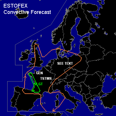
There is a slight risk of severe thunderstorms forecast across southwestern France
There is a slight risk of severe thunderstorms forecast across northern Germany and northwestern Poland
SYNOPSIS
Monday at 06Z... A longwave trough is located near a line from Scandinavia to southwestern Europe. Most of western Europe is in a neutral polar air mass that will destabilise as a result of solar heating. A northwesterly mid/upper level jet streak is located from Ireland towards northern Spain and is moving southeastward. During the second half of the forecast period a shortwave trough will develop in the jet's exit region over the western Mediterranean.
DISCUSSION
...southwestern France...
The strong mid/upper jet over the Bay of Biscay provides ample shear
for storm organisation in southwestern France.
Synoptic-scale ascent, solar heating and strong wind shear set the stage for
strong convection. The convection will likely be organised
in line segments and mini-supercells. Especially the latter type
will be capable of producing
strong and severe wind gusts and 2-3 cm hail. Anticipated rather low LCL's
indicate one or two tornadoes are possible. The threat of severe storms will diminish around sunset.
...northern Germany, northwestern Poland...
northern Germany, northwestern Poland
A mid-level vorticity maximum located over the northern
Netherlands is expected to move eastward into northern Germany
and northern Poland. On its southern and eastern flanks
15-20 m/s wind shear in the lowest 3 km was observed. This area of strong
shear is expected to move eastward with the system.
As thunderstorms redevelop due to solar heating over western continental
Europe, storms will likely become well-organised in this area of strong shear.
Likely modes of organisation over include linear segments possibly
with embedded rotating updrafts. Wind gusts around 25 m/s and 2-3 cm
hail could occur with these storms. Cloud bases are expected to remain
quite low so that one or two tornadoes could occur. During the afternoon,
threat will diminish from the west as shear decreases.
#