CONVECTIVE FORECAST
VALID 06Z SAT 20/03 - 06Z SUN 21/03 2004
ISSUED: 20/03 01:20Z
FORECASTER: GROENEMEIJER
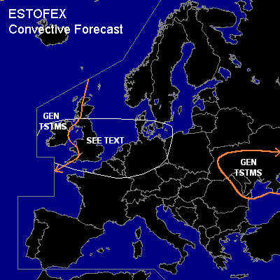
General thunderstorms are forecast across the western Ukraine, Moldova, northeastern Romania
General thunderstorms are forecast across western parts of the British Isles
SYNOPSIS
A very strong 80 m/s jet streak is forecast to move into western Europe. A deepening surface cyclone is expected to move eastward from a few 100s of km north of Ireland at Saturday 06Z to southern Scandinavia by sunday 06 Z. Downstream, a weak trough over western Poland is expected to intensify and move eastward to reach a line from central Finland to the western Russian Federation to the eastern Ukraine at the end of the forecast period.
DISCUSSION
...Ukraine, Romania, Moldova...
Thunderstorms are expected to (re) develop during the day over the western Ukraine and possibly along the Black Sea coast of Romania. The activity over the Ukraine is expected to spread eastward with the upper trough during the day. Severe thunderstorms are not expected because of the low amount of instability and marginal wind shear.
...See text area and the westewrn British Isles GEN TSTMS area...
cold front of the aforementioned cyclone is expected to progress eastward during the day. Several baroclinic waves may form along the front. The GFS forecast shows strong low level lapse rates and relatively high SFC dew points and low level shear in the 15-25 m/s range. This, in combination with the likely development of a split front pattern suggest that linearly organised shallow convection can form along the cold front. This may happen in the early morning over Ireland and southern England but is more likely as it approaches continental Europe. There will be a small chance of severe wind gusts and - given that LCL height are forecast to be very low as well - a few tornadoes. At this moment we will refrain from issuing a categorical risk, since it is not possible at this moment to pin point a specific area in which the threat would reach this risk level. An update may be issued later on.
Late Saturday evening and the following night, convection in a polar air mass is expected to affect the western British Isles. Shear profiles are expected to have weakened somewhat by then and models do not suggest a strong system will develop within this air mass so that the threat of any sever weather will be quite limited.
#