CONVECTIVE FORECAST - UPDATE
VALID 12Z THU 18/03 - 06Z FRI 19/03 2004
ISSUED: 18/03 07:28Z
FORECASTER: VAN DER VELDE
General thunderstorms are forecast across the same areas as latest Convective Forecast
SYNOPSIS
DISCUSSION
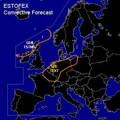
...NRN France, Benelux, NWRN Germany...
Update: 00Z ini GFS model seems to reflect the weaker potential for CAPE to develop, as was expected in the latest Convective Forecast due to significant dryness in the 12Z and now also 00Z Trappes and Bordeaux soundings. Indicated LFCs are higher and the better forecast CAPEs are now more southward, still within the drawn GEN TSTMS area.
Although GFS WBPT of 12C is consistent with Trappes and Bordeaux, with 850 hPa temps of 10-12C in the soundings at 00Z also reflected in GFS ... but the cooling of some 4 degrees has yet to take place and needs lift. The model update may indicate a trend towards slightly less midlevel cooling than previous indications. Even so, there will be a fairly dry layer below a saturated layer and on top of fairly shallow BL moisture.
The main mode seems to be larger scale rain with embedded multicell convection. Given the good shear conditions, a marginal threat of severe weather as indicated in the latest Convective Forecast may still be possible where things come together for more organised convection.
...SW-C France...
SFLOCS near the SW France coast this morning seem to relate to the 00Z elevated instability in the Santander sounding. As this air is advected over SW France and is not reflected well in CAPE fields, this area may require a GEN TSTMS if 12Z Bordeaux shows instability as well, with perhaps some daytime heating (not much considering the cloudiness).
At least moisture here seems adequate enough. Did not have the time to reflect this area in map.
#