CONVECTIVE FORECAST
VALID 06Z TUE 16/03 - 06Z WED 17/03 2004
ISSUED: 15/03 22:10Z
FORECASTER: HAKLANDER
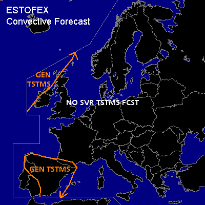
General thunderstorms are forecast across the extreme NWRN British Isles.
General thunderstorms are forecast across most parts of the Iberian Peninsula.
SYNOPSIS
A SWLY jet to the NW of the British Isles bends back SEWD across Scandinavia. South of this jet, a strong upper ridge dominates across most of Central and SRN Europe. Main weather feature across the Mediterrean is a quasi-stationary ULL over SE-Spain, which slowly migrates inland. Monday's Meteosat IR imagery showed a weakening occlusion band across NRN Algeria and the Balearic Islands, spiraling towards the ULL core.
DISCUSSION
...Iberian Peninsula
...
Monday's GFS12Z forecast soundings indicate that about 200-500 J/kg CAPE should build across parts of the Iberian Peninsula during Tuesday, with negligible CIN. Furthermore, slightly negative Showalter Index values imply the presence of a relatively deep layer (surface to 850 hPa) with positive CAPE. This should enable the formation of a few thunderstorms. Given the marginal CAPE and low vertical wind shear, severe weather is not expected.
...NWRN British Isles
...
Behind the cold front with which the SWLY jet is associated, low CAPE within the polar air mass could yield a few lightning strikes. Although deep layer shear inside the positive CAPE area could reach 20 m/s, severe weather is considered unlikely due to the low amount of CAPE.
#