CONVECTIVE FORECAST
VALID 06Z THU 11/03 - 06Z FRI 12/03 2004
ISSUED: 11/03 04:11Z
FORECASTER: VAN DER VELDE
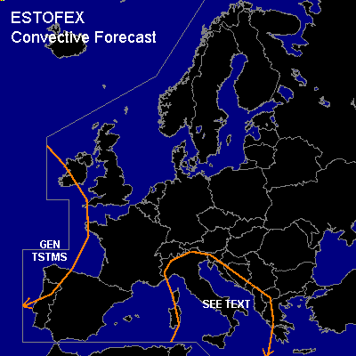
General thunderstorms are forecast across the central Mediterranean Sea, Italy, Adriatic Sea, western Balkan
SYNOPSIS
Between a sfc high pressure area over NE Europe and approaching Atlantic low pressure, an increasing southeasterly flow is set up over western Europe by Friday. In the upper air, a cold pool over Switzerland sinks over Italy. Its associated CVA max and WAA underneath result in development of a SFC low pulling up higher theta-e's below the cold upper air, leading to destabilisation. Currently this wave is visible in IR/WV imagery.
DISCUSSION
...the central Mediterranean Sea, Italy, Adriatic Sea, western Balkan...
GFS 12Z CAPEs are weak and sporadic, however thunder should be possible as midlevel lapse rates will be near saturated conditions, with BL theta-e values increasing. Current 00Z soundings show fairly sufficient steep lapse rates, e.g. the elevated instability in Trapani, and significant low-midlevel potential instability in Pratica di Mare.
Although forecast latent instability will be weak, elevated terrain and abundant sfc convergence will produce sufficient low level lift to trigger convection along the theta-e ridge (cold front/occlusion). However, insolation is not expected to be a good contributor since the area is covered by clouds for the greater part.
SREH values are forecast by GFS 12Z to be in the order of a good 150-300 m²/s², with deep layer shear values in the low end for supercells. However, most instability is within the SFC trough, lagging the forecast SREH values. Strong veering and increasing winds are also observed in 00Z soundings at the west side of the area. If convection may happen within these strong SREH areas, rotating updrafts could form that may cause intense phenomena such as marginally large hail. The low LCLs in the area may be supportive of a tornado chance as well, especially in areas where 0-1 km shear is enhanced. Values forecast by GFS reach over 20 kts in places, but may be even more enhanced by topography. The amount of latent instability is the critical factor, and ATTM not enough to warrant a SLGT RISK.
#