CONVECTIVE FORECAST
VALID 06Z FRI 27/02 - 06Z SAT 28/02 2004
ISSUED: 27/02 03:09Z
FORECASTER: VAN DER VELDE
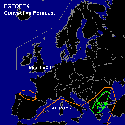
There is a slight risk of severe thunderstorms forecast across northern Greece into southern Romania
General thunderstorms are forecast across most of the Mediterranean, southern Gulf of Biscay
SYNOPSIS
Large upper trough is dominating much of Europe.
Within the upper trough and over/near sea areas, wintry showers with sparse thunder are likely. More polar low-ish disturbances have developed in the last 24 hours and will affect eastern UK and mostly the southwest coast of The Netherlands. Lightning will be very sparse, as the previous days have not shown much activity either. This time decided not to give out a GEN TSTMS area anymore.
A smaller upper trough has enhanced convection from the western British Isles into the Gulf of Biscay, with instability deep enough for some sparse thunder. A SFC low will develop over southwestern France at the approach of the upper shortwave. This development will dominate the weather mostly on Saturday in most of the Mediterranean.
A SFC low that developed Thursday afternoon over the central Mediterranean is migrating into the northern Balkan. At the south side, a plume of higher theta-e and SFC convergence pulls up over the southern Balkan in a strongly forced and strongly sheared environment. IR imagery shows a slight wave moving towards the area by 00Z.
DISCUSSION
...northern Greece into southern Romania...
Deep layer shear 50-70 kts, SREH up to 200 m2/s2 and forcing seem to be enough for low topped supercells to develop, especially as the theta-e ridge/cold front wave with associated convergence advances over the area. Currently, this theta-e gradient at the left jet exit generates convection over Sicily/SRN Italy.
CAPE values are forecast to be marginal, up to 500 J/kg, in practice likely less, but the previous day showed that isolated storms formed in the same airmass. The wetbulb potential temperature will be 2-3 degrees higher compared to previous day, with pressure falling and favorable timing . Low-medium LCLs, 0-1 km shear >20 kts will pose a risk of an isolated tornado with well organised cells, besides the chance of marginally large hail. The linear forcing may initiate a squall line with enhanced gust potential.
...western Mediterranean...
Developing depression will pick up some higher theta-e and cold air aloft will combine to an unstable environment capable of fairly widespread thunder, especially near SFC convergence and upper vorticity advection areas as the SFC low moves east later in the forecast period.
...Sea around the British Isles...
Sparse lightning may occur in well-organised convective structures.
#