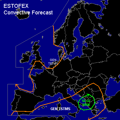
CONVECTIVE FORECAST
VALID 06Z THU 26/02 - 06Z FRI 27/02 2004
ISSUED: 26/02 02:41Z
FORECASTER: VAN DER VELDE
There is a slight risk of severe thunderstorms forecast across the Albania area
General thunderstorms are forecast across coastal zones of Western Europe, except the English Channel (very weak activity)
General thunderstorms are forecast across much of the Mediterranean, Italy, and the Balkan
SYNOPSIS
Large upper trough is expanding southward. Within the upper trough and over/near sea areas, wintry showers with sparse thunder are likely. Currently, a polar low that developed in the last 24 hours lies off the west coast of The Netherlands, and another one seems to develop right behind it. While the first polar low is well detectible from e.g. GFS 18Z model sfc convergence pattern, this second possible polar low is not represented. Winds are higher around the south side of the polar low, but will calm down after 12Z. Lightning will be very sparse, as the previous days have not shown much activity either.
A smaller upper trough swings over the western British Isles into the Gulf of Biscay, with instability deep enough for some sparse thunder. A SFC low will develop over southwestern France at the approach of the upper shortwave.
A thundery SFC low over the south Iberian Peninsula will deepen at its WAA side and move from the western mediterranean towards the Balkan during the forecast period. Several areas of 500 hPa PVA and instability up to a few hundreds of CAPE will generate some thunderous convection, especially near the SFC cold front near the Baleares/Corsica-Sardegna. Off the Tunesian coast towards the east, elevated convection with MUCAPE possibly over 500 J/kg is transported towards the western/southern Balkan.
DISCUSSION
...southwestern Balkan...
Mostly elevated convection across the theta-e ridge, however, GFS indicates lowering of the LFC around the Albania corner of the Balkan. Storm-Rel Helicity values are expected to reach 150-300 m2/s2 and deep layer shear 45-70 kts over 0-6 km. These indicate potential for low topped supercells with a chance of marginally large hail.
A slight chance of a tornado is not ruled out if convection is surface-based, since 0-1 km shear values are expected to be around 25 kts, with low LCLs.
#