CONVECTIVE FORECAST
VALID 06Z TUE 24/02 - 06Z WED 25/02 2004
ISSUED: 23/02 23:09Z
FORECASTER: HAKLANDER
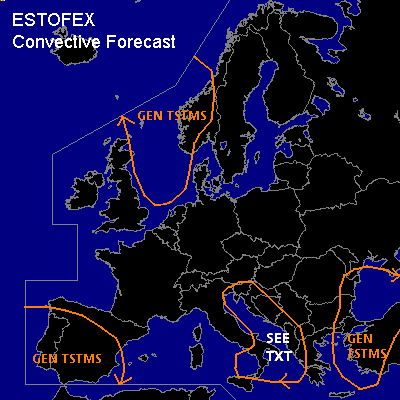
General thunderstorms are forecast across the North Sea and SW Norway.
General thunderstorms are forecast across much of the Iberian Peninsula.
General thunderstorms are forecast across the Adriatic coasts and Sea, parts of the Tyrrhenean and Ionean Seas.
General thunderstorms are forecast across the Aegean Sea, NW Turkey, the Black Sea and its west coast.
SYNOPSIS
East of an Atlantic omega block, a well-developed surface cyclone near the Norwegian west coast (Trondheim area) is expected to drift SEWD very slowly. Maritime arctic air behind its cold front should spread SWD across the North Sea during the FCST period. On the upper air charts, this system can be identified as an area of low geopotential across Scandinavia, with a trough extending SWWD across the Bay of Biskay towards a separate ULL W of Portugal. A small upper air disturbance near Liechtenstein at TUE/06Z should cross the northern Adriatic Sea and Croatia to reach Romania at WED/06Z. At the surface, this upper air feature is found behind a cold front crossing the Adriatic Sea from the NW during TUE. Across the Mediterranean Sea, a westerly flow of about 20 m/s is present at 500 hPa.
DISCUSSION
...North Sea, SW-Norway
...
MUCAPE should increase to a few hundred J/kg, as the arctic air mass spreads across the area. At 700 hPa, temperatures could drop to -25°C and at 500 hPa, temperatures below -40°C are possible, while SSTs are 7-8°C. Given little or no convective inhibition and the implication of deep convection by negative SLI values, some storms are expected to become thundery. Vertical wind shear behind the frontal zone ahead of the zone with positive MUCAPE decreases rapidly, limiting vertical momentum transport within downdrafts.
...Iberian Peninsula...
Areas of increased latent instability are located near the core of the ULL and in its old, warm sector, especially just ahead of the cold front. MUCAPE should, however, remain below 500 J/kg. Even along the cold front, deep layer shear should be only 15 m/s. Considering the weak CAPE, thunderstorm activity is expected to be non-severe.
...Adriatic Sea, Albania...
The aforementioned small upper air disturbance crossing the NRN Adriatic Sea is accompanied by an intense jet streak to its south. According to GFS 12Z, deep layer shear of 70-80 kts is possible and considering the presence of some CAPE there (~100 J/kg), storms could organize along the cold front and produce convective wind gusts approaching severe limits. If thunderstorms develop and reach the Adriatic coast, one or two cells could even exhibit mini-supercell characteristics, due to orographically induced low-level wind shear. However, the amount of CAPE seems too low for this scenario at present and thunderstorms may not even develop at all.
#