CONVECTIVE FORECAST
VALID 06Z MON 23/02 - 06Z TUE 24/02 2004
ISSUED: 23/02 09:53Z
FORECASTER: GROENEMEIJER
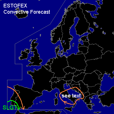
There is a slight risk of severe thunderstorms forecast across the southwestern Iberian Peninsula
General thunderstorms are forecast across western, southwestern and southern parts of the Iberian Peninsula, central Italy, the southern Adriatic and a part of the western Balkan coast.
SYNOPSIS
Monday at 06Z... a westerly mid and upper level flow was located over the western half of the Mediterranean. A vorticity maximum was located over northeastern Spain and a shortwave trough associated with a cold front was located along a line from Denmark to western France. A mid/upper- level low pressure area was located to the west of northern Portugal. Water vapour imagery shows a shortwave trough over the Canary Islands moving northeastward.
DISCUSSION
...southeastern Iberia...
Deep convection is ongoing mostly off-shore near the core of the mid/upper-level low. Isolated, mostly non-thundering storms are present over southern Spain. On approach of the Canary shortwave trough, warm advection is expected to increase over the area and a quite helical and strong low-level wind regime is forecast. Marginal instability already being in place per 00Z Gibraltar sounding, is expected to increase to a few 100's J/kg MLCAPE over the entire area.
Since satellite and SFLOC data reveal that storms are ongoing near the trough axis/ and given that strong WAA and DCVA related forcing for upward motion will overspread the area/ widespread convection is forecast this evening and night. Because of the mature stage of the system most convection will likely be clustered into a MCS. However, a few supercells, possibly embedded in larger convective systems, will likely form. These may be accompanied by strong gusts and marginally severe hail. Low LCL heights and strong low level shear imply that few tornadoes may occur as well.
...central Italy, central Adriatic and the western Balkan coast...
The shortwave trough over northern Spain is expected to move rapidly eastward and is expected over Italy at the end of the forecast period. A few storms will probably form ahead of the trough in the GEN TSTMS area. Strong unidirectional wind shear profiles and low instability -on the order of a few 100's J/kg- are forecast. Expect the storms to organise into a few convective systems. Chance of rotating updrafts seems not to be too high because of the combination of unidirectional shear and low instability. Therefore, only a small threat of some strong wind gusts and marginally severe hail is anticipated and a categorical risk is not issued.
#