CONVECTIVE FORECAST
VALID 06Z THU 19/02 - 06Z FRI 20/02 2004
ISSUED: 19/02 12:27Z
FORECASTER: VAN DER VELDE
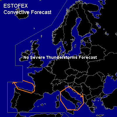
General thunderstorms are forecast across the southern Gulf of Biscay
General thunderstorms are forecast across Italy, Adriatic/Mediterranean
SYNOPSIS
Dipole situation with a strong blocking high pressure area stretching from Ireland to Sweden that keeps much of Europe free of convection. Low pressure in southern parts and a westward moving upper low over southern France. A SFC low near Italy and associated cold front/wave moves eastward but will eventually flatten out into a west-east oriented front as cold air pushes southward from the continent.
DISCUSSION
...Italy, Adriatic/Mediterranean...
Due to shallow instability (tops around -15C) but good forcing along the advancing wave, marginal thunder activity should be possible. GFS forecasts a good deal of convective precip. CAPE is expected to increase southeast of Italy in the second half of the forecast period, so this may see slightly more activity.
Shear conditions 0-6 km are 50 kts, but since tops are so low, shear in the convective layer is only in the 10-25 kts range and severe weather is not likely.
...southern Gulf of Biscay ...
and coastal areas: Thunder will be possible at a 500 hPa vorticity maximum of the upper low, collocated with a SFC trough. A somewhat convective looking IR satellite feature is seen moving southwestward towards the Gulf. The upper low is forecast to deepen over the GEN TSTMS area, deepening the layer of moist convection. Low level lapse rates / instability increase as the cold air spreads over the Gulf.
#