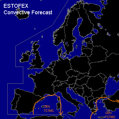

CONVECTIVE FORECAST
VALID 06Z TUE 17/02 - 06Z WED 18/02 2004
ISSUED: 16/02 18:36Z
FORECASTER: HAKLANDER
General thunderstorms are forecast across the WRN Mediterrean Sea, the Balearic Islands, Corsica and Sardinia.
General thunderstorms are forecast across the Aegean Sea, Crete, parts of Turkey and the ERN Mediterranean Sea.
SYNOPSIS
An upper ridge of increasing amplitude, with main axis across Ireland, is perturbed by cold pockets of enhanced vorticity at mid and upper levels at its ERN flank. At TUE/06Z the first disturbance is forecast across NERN Spain, which should cross the Balearic Islands during TUE. A second cold pocket should cross the English Channel, reaching SRN France at WED/06Z. Meanwhile, a broad upper trough across the Ionean Sea, the Balkan, and the Aegean Sea migrates EWD towards Turkey and the ERN Mediterranean. At low levels, cyclogenesis is forecast near the SW Turkish coast during TUE.
DISCUSSION
...WRN Mediterranean
...
DCVA related upward motion combined with MUCAPE values exceeding 500 J/kg should result in several thunderstorms. Both deep layer and low level wind shear are expected to remain too low (about 30 and 10 kts, respectively) for severe storm development.
...ERN Mediterranean...
With relatively cold air at mid and upper levels, a few hundred J/kg MUCAPE should be present across the area, with little or no convective inhibition.
A band with deep layer shear exceeding 30 kts could partly overlap with the positive CAPE area near the cold front of the aforementioned surface cyclone, but considering the low amount of CAPE, the forecast kinematic setup does not seem sufficient for severe storms.
#