CONVECTIVE FORECAST
VALID 06Z FRI 13/02 - 06Z SAT 14/02 2004
ISSUED: 13/02 01:32Z
FORECASTER: VAN DER VELDE
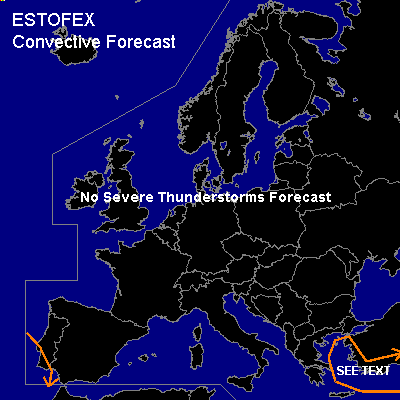
General thunderstorms are forecast across the Eastern Aegean Sea / South coast of Turkey
General thunderstorms are forecast across Southwest Iberian Peninsula
SYNOPSIS
Same as yesterday, in fact.... Strong high pressure over Western Europe keeps most of Europe free of deep convection, but is slightly eroding. The cold air boundary over estern Central Europe slowly recedes to the east. A deep upper low (500 hPa @ <512-520 dam) is cut off and will linger over the Black Sea with accompanying surface low. A very weak upper low cuts off and may affect the southwest of the Iberian Peninsula.
DISCUSSION
...Eastern Aegean Sea / South coast of Turkey ...
Some thunder is possible near the Turkish south and west coast, especially along the warm side of the SFC cold front. Shallow convection in the cold air mass over the Aegean Sea may occasionally produce some thunder.
For the eastern Aegean Sea/Turkish southwest coast:
Given very steep low level lapse rates (25-30 deg sfc-1 km, superadiabatic), very low LFCs generally below 600 meters and ample low level instability, together with low 0-1 km vertical windshear and high vorticity, chances for waterspouts seem very favorable.
The GFS 12Z model indicates more low level instability than yesterday, with 925-700 hPa average Lifted Index of -1 deg. Midlevel ascending motion and model-indicated convective precipitation will remain in the area at the vorticity maxima of the upper trough.
#