CONVECTIVE FORECAST
VALID 06Z TUE 27/01 - 06Z WED 28/01 2004
ISSUED: 26/01 22:07Z
FORECASTER: HAKLANDER
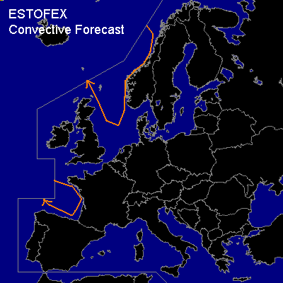
General thunderstorms are forecast across the Norwegian and North Seas, the Bay of Biskay
SYNOPSIS
High-amplitude, quasi-stationary Rossby wave pattern is present across most of Europe. The main trough is situated across the North Sea, with very cold air at midlevels. This could yield several hundreds of J/kg MUCAPE across the Norwegian and North Sea. Therefore, a few lightning discharges cannot be ruled out. A pocket of relatively cold midlevel air across the Bay of Biskay could suffice for a few thundery showers there as well. At more locations across Europe, a few lightning strikes might occur due to positive CAPE and little CIN, but thunderstorm risk appears too conditional for a GEN TSTMS area. Therefore, we will mention here that some light thunderstorm activity is not ruled out across the Tyrrhenean, Aegean and Ionean Seas. Severe storms are not expected, mainly due to the insufficient amount of CAPE.
DISCUSSION
#