CONVECTIVE FORECAST
VALID 06Z THU 15/01 - 06Z FRI 16/01 2004
ISSUED: 15/01 08:14Z
FORECASTER: VAN DER VELDE
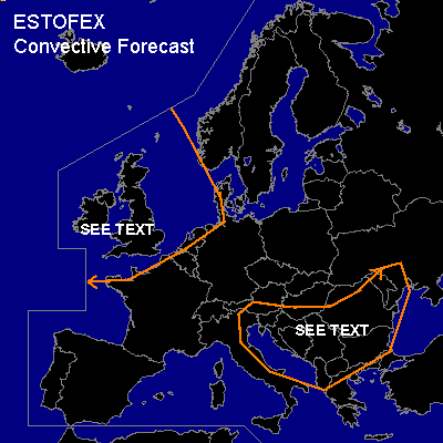
General thunderstorms are forecast across the British Isles, the west coast of France, and the North sea
General thunderstorms are forecast across the Adriatic Sea and the Balkan
SYNOPSIS
With a slightly northwesterly upper level flow over western Europe, a low west of Ireland migrates over the British Isles and deepens from 990 hPa to below 975 hPa according to GFS. Another low deepens while migrating over the Balkan. There appears to be no significant instability over land areas during most of the forecast time.
DISCUSSION
...British Isles...
There is a slight chance of an isolated tornado at the back side of the the cold front and around the occlusion passing over Ireland and south/central UK in the 18Z-06Z, given the unstable air and quite strong low level shear (>20 kts 0-1 km), moderate to strong deep layer shear (> 30 kts 0-6 km), combined with moderately low LCLs/LFCs (500-1000m). SRH values are 250m2/s2 near the occlusion which may promote more sustained mesocylone formation in low topped cells that may form. Sfc convergence and vorticity are abundant.
CAPE values from GFS 00Z seem not significant, but vertical cross sections of buoyancy along with integrated low level buoyancy seem supportive of convection, with modest amount of thunder. Model convective precip seems to support this.
...Adriatic Sea, Balkan...
Sporadic/weak instability inland over the Balkan is expected, but with ample forcing and strong shear conditions and moderate/low LFCs isolated tornadoes might form, especially where SRH may be orographically enhanced.
#