CONVECTIVE FORECAST - UPDATE
VALID 06Z TUE 13/01 - 06Z WED 14/01 2004
ISSUED: 13/01 14:16Z
FORECASTER: HAKLANDER/GATZEN
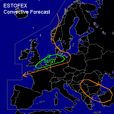
There is a slight risk of severe thunderstorms forecast across Southern Great Britain, The Low countries, northern Germany
General thunderstorms are forecast across NWRN Europe
General thunderstorms are forecast across SERN Europe
SYNOPSIS
At TUE/06Z, a strong jetstream of 140+ kts at 300 hPa is forecast across the SRN British Isles and the Benelux countries, extending toward the WRN Balkan. This jet slowly moves SWD and should end up between 45-50N, across France and the Alps, by WED/06Z. A trough at low and mid levels is expected to reach the WRN North Sea by TUE/06Z, after which it broadens and progresses EWD towards SRN Sweden, forming a closed low. A second trough should reach the Celtic Sea by WED/06Z. Across ERN Europe, the upper flow diverges.
DISCUSSION
...NWRN Europe ...
Low MUCAPE of at most several hundreds J/kg is forecast across large parts of the GEN TSTMS area. Across the NWRN British Isles, negative Showalter Index values suggest that CAPE should be present up to 850 hPa, which implies the presence of a relatively deep layer of latent instability for this time of year. Across most of the low CAPE area, deep layer shear will remain < 40 kts and 0-1 km layer shear is expected to remain below 30 kts. However, before TUE/18Z, the southernmost part of the area might partly overlap the high wind shear area across extreme SRN England, the Benelux countries and West/Central Germany. If any thunderstorm should form across this high wind shear area before TUE/18Z, then it should be monitored closely, because 0-1 km shear of 35-40 kts might enable it to develop a rotating updraft and become a mini-supercell. Latest model output suggests that upward vertical motion over the mentioned region will be stronger than expected ... with an upper short-wave trough moving eastward over The Low countries and northern Germany. If organized convection could form underneath this trough ... severe thunderstorms should form over southern Great Britain and The Low countries ... reaching northeastern Germany in the evening. Convection may merge into small bow echoes. Severe wind gusts should be rather likely with this convection. There is also a slightly enhanced threat of tornadoes and hail.
#