CONVECTIVE FORECAST
VALID 21Z MON 12/01 - 06Z TUE 13/01 2004
ISSUED: 12/01 19:17Z
FORECASTER: GROENEMEIJER
There are no thunderstorms forecast.
SYNOPSIS
A strong westerly jet is located over the Atlantic Ocean. A low-pressure system is located over west-central Germany at 19Z, moving eastward. Another, intense low=pressure system is located west of Ireland, moving eastward.
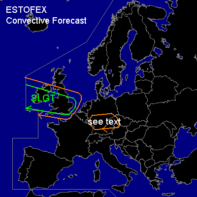
DISCUSSION
...British Isles...
A line of thunderstorms is moving rapidly eastward to the southeast of the latter low pressure system. In the early evening these will spread over Irland and work their way eastward into Great-Britain reaching the southern North Sea around 06Z. Very strong shear is forcast near the storms, that may well have embedded mesocyclones (i.e. embedded mini-supercells). Although the storms are located to the east of the greatest sea-level pressure gradient, the storms should be capable of producing strong gusts well in excess of 50 knots. Additionally, there is a threat of tornadoes with the storms. More storms may form to the west of the current line of storms.
...Germany, Czech Republic...
Some weak storms, are present over western Germany. There is a chance that a few stronger convective storms will form during the next few hours. If this occurs, the storms may bring severe weather, since wind shear is very high.
#