CONVECTIVE FORECAST - UPDATE
VALID 16Z SUN 11/01 - 06Z MON 12/01 2004
ISSUED: 11/01 16:29Z
FORECASTER: GROENEMEIJER
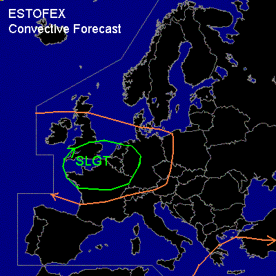
There is a slight risk of severe thunderstorms forecast across southeastern Ireland, the southern UK, northern and western France, western Germany and the Low Countries.
General thunderstorms are forecast across much of western Europe and across the eastern Mediterranean
SYNOPSIS
Strong zonal jet is located over the Atlantic. A shortwave trough located near Ireland at 12Z is moving eastward. DCVA ahead of this system is sustaining organised convection over northwestern France. Downstream cyclogenesis is taking place in the left exit region of a jet streak over the mid-Atlantic. The cyclogenesis will likely intensify late Sunday night/early Monday morning and a small, deepening cyclone with strong winds on its southern flanks is expected near southern Ireland at the end of the forecast period.
A vort max south of Crete is pivoting around the base of an eastern European upper long-wave trough and affects the south-central Mediterranean Sea. SFC low ATTM over the S Aegean ... will slowly track eastwards along the Turkish S coast.
DISCUSSION
...Britain, France, the Low Countries and Germany....
Strong rising motions ahead of a shortwave trough from southeastern England southward, is sustaining an MCS currently moving into northwestern France. To the north... over southern England and the Low Countries new organised convection is forming. The combination of strong low-level shear (around or above 30 kts in the 0-1 km layer) and strong synoptic forcing will favour linearly organised convection with the chance of embedded mesocyclones. These could locally bring gusts well in excess of 50 kts and a few tornadoes in addition to a small risk of hail exceeding the severe limit of 2.0 cm. The risk of tornadoes is expected to decrease over England from the west during the evening hours as somewhat drier boundary layer air is flowing from the west. After midnight the overall convective threat will probably increase over the continental part of the risk area as well.
...eastern Mediterreanean...
Refer to the lastest forecast.
#