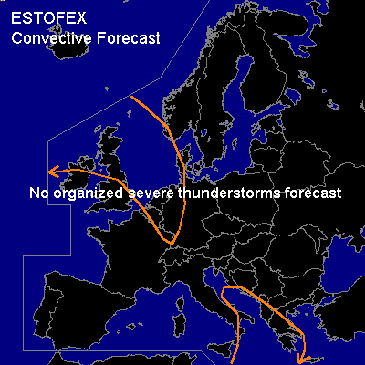

CONVECTIVE FORECAST
VALID 06Z FRI 09/01 - 06Z SAT 10/01 2004
ISSUED: 08/01 18:47Z
FORECASTER: GATZEN
General thunderstorms are forecast across NWRN Europe
General thunderstorms are forecast across E-CRTL Mediterranean
SYNOPSIS
Weak upper long-wave trough placed over ERN Europe. Over the NERN Atlantic ... very strong upper jet stream (more than 80 m/s @ 300 hPa) is present S of an intense long-wave trough. Delta of this strong jet has reached WRN Europe and propagates southeastward into CTRL Mediterranean. Over NRN Europe ... weak ridge will resist between both troughs over Scandinavia.
DISCUSSION
...NWRN Europe
...
Strong surface low pressure system analyzed over NRN Great Britain will move ENEward reaching Iceland tomorrow morning. Its cold front will cross NWRN Europe running from SRN France to ERN Germany and further to Iceland at 12Z. W of this cold front ... convectively mixed airmass over Great Britain and NWRN France will be present over Great Britain, the North Sea, NRN France, Benelux, Denmark and WRN Germany. CAPE values in the order of some 100s J/kg are expected within this airmass as indicated bs today's LFRB Brest sounding. During the FCST period ... upper ridge over SWRN Europe will amplify as upper jet streak will turn SEward into CRTL Mediterranean. The axis of this jet streak is FCST to reach from Great Britain to ERN France and WRN Italy at 18Z. Along the cyclonal flank ... sharp upper trough is FCST over the North Sea, CRTL Germany, and N-CTRL Mediterranean, where DCVA is expected. Showers and isolated thunderstorms are FCST in the range of the trough axis mostly over the North Sea. Due to the strong pressure gradient ... strong wind gusts should be likely. Organized severe thunderstorms are not expected though.
...E-CRTL Mediterranean...
As the strong upper jet approaches ... DCVA is forecast ... and cyclogenesis is expected over NRN Mediterranean. S and E of the forming surface low ... relatively unstable airmass is advected into E-CRTL Mediterranean. Along the cold front that is FCST W of Greece at the end of the FCST period ... showers and thunderstorms are FCST. Weak instability and realtively weak vertical shear are expected, and severe thunderstorms are not FCST ATTM.
#