CONVECTIVE FORECAST
VALID 12Z WED 07/01 - 06Z THU 08/01 2004
ISSUED: 07/01 12:42Z
FORECASTER: GROENEMEIJER
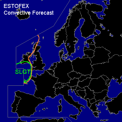
There is a slight risk of severe thunderstorms forecast across Extreme southern Ireland, extreme western England and Wales and across extreme western France.
General thunderstorms are forecast across western parts of the British Isles
SYNOPSIS
At 12Z a mid/upper low is located over Turkey and a ridge is located along a line from the central North Sea to near the Baleares. The ridge is expected to move eastward quite slowly. A strong westerly jet is approaching western Europe.
DISCUSSION
...Extreme southern Ireland, extreme western England and Wales, extreme western France....
At 12Z, a north-south oriented cold front that marks the leading edge of a convectively mixed polar air-mass, is located over the Irish Sea. It is forecast to continue its eastward motion.
Behind the front....a sharpening northwest-southeast oriented shortwave colocated with the exit region of a strong (100 kt @ 500 hPa) westerly jet is expected to approach the southern British Isles after midnight and reach a line from just west of Ireland to just west of Bretagne at 06Z.
Strong quasi-geostrophic forcing for upward vertical motion is forecast ahead of the trough. The thunderstorms already present ahead of the trough will likely cluster in one or two linear convective systems, that may affect southern Ireland around midnight and extreme western parts of Wales, Engalnd and Bretagne just before the end of the forecast period.
Quite strong low-level and deep-layer shear suggest that strong and severe wind gusts will locally occur with the convective systems. It is well possible that some embedded mesocyclones form, especially across extreme western France and England, where low-level storm-relative helicity will be the highest. This will yield a small hail threat and an enhanced threat of strong gusts. LCL-levels are expected to be quite low given projected 14/10 T/Td values, suggesting that a few tornadoes are possible as well. Over southern England and France, the threat will likely persist during the first hours of the next forecast period.
#