CONVECTIVE FORECAST
VALID 06Z THU 01/01 - 06Z FRI 02/01 2004
ISSUED: 31/12 18:08Z
FORECASTER: GATZEN
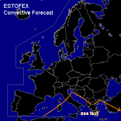
General thunderstorms are forecast across central and eastern Mediterranean
SYNOPSIS
Long-wave trough placed over Europe ... and polar jet stream extends from Great Britain to the western Mediterranean into northern Africa and further to the eastern Mediterranean. Several vort-maxima are travelling around the troughs periphery. A vort-max over northern Africa at the beginning of the forecast period will cross the southern Mediterranean reaching the eastern portions on Friday. Another vort-max is forecast over western Europe and should affect the western Mediterranean ion Friday.
DISCUSSION
...Mediterranean
...
Today's observations indicate convective activity over the southwestern, the central and eastern Mediterranean. The affected airmass is characterized by weak CAPE within the lowest kilometers and moderate to strong deep layer shear. Tomorrow ... cold and stable airmass is expected over the western portions, while CAPE should still be present over the central and eastern parts. As the vort-max crosses the southern and eastern Mediterranean ... synoptic scale uvm is expected and showers and thunderstorms should form. Model output suggests weak low level westerly winds and relatively strong westerly winds at 850 hPa, yielding moderate low-level wind shear. Low-level winds should not veer with height and high helicity values are not expected. Therefore, risk for severe weather should be quite low.
#