CONVECTIVE FORECAST
VALID 06Z TUE 23/12 - 06Z WED 24/12 2003
ISSUED: 22/12 21:26Z
FORECASTER: HAKLANDER
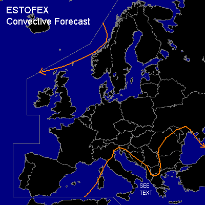
General thunderstorms are forecast across the extreme NRN British Isles and the Norwegian Sea.
General thunderstorms are forecast across Corsica, Sardinia, the Central and ERN Mediterranean, parts of the Balkan, Turkey and the Black Sea.
SYNOPSIS
Longwave quasi-stationary upper trough across Finland and Poland towards Italy cuts off a closed low near SRN-Italy/Sicily, as the upper flow zonalises across Scandinavia. Meanwhile, a strong upper ridge W of Portugal and Ireland slowly retreats SSEWD as CAA across the NRN Atlantic causes a SWD movement of the polar jet.
DISCUSSION
...SERN Europe...
Cold air at upper levels combined with relatively moist and warm air near the surface should result in several hundreds of MUCAPE.
MON/12Z soundings indicated some potential for severe weather, with > 300 J/kg MLCAPE at Ajaccio and about 55 kts deep layer shear.
However, the band of strongest deep layer shear will have moved towards NRN Africa by TUE.
Moderate shear of 40+ kts will likely still be present across the Ionean Sea, but due to the low CAPE, severe weather seems unlikely.
...Extreme NWRN Europe...
Very stable MULI's of > +10K seem misleading, according to GFS forecast soundings.
With marginal CAPE and EL's below 600 hPa at about -15°C, thunderstorms could form in the polar air mass that should reach the area late TUE, early WED.
Low level winds and shear seem too weak to warrant a SLGT, but severe convective wind gusts cannot be ruled out either.
#