CONVECTIVE FORECAST
VALID 06Z MON 22/12 - 06Z TUE 23/12 2003
ISSUED: 22/12 00:39Z
FORECASTER: GROENEMEIJER
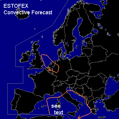
General thunderstorms are forecast across the central Mediterranean Sea region as well as the southern North Sea, the Benelux countries and a part of western Germany.
SYNOPSIS
A trough over central Europe is rapidly digging southward. On the western flank of a surface cyclone over the Baltic Sea...a polar/arctic air-mass is being advected southward over the North Sea and western continental Europe and southeastward into central Europe. As the polar air spreads over the warm central Meditteranean during this forecast period, the resulting instability is expected to give rise to a couple of thunderstorms.
DISCUSSION
...Central Mediterranean...
At the beginning of the forecast period, the cold front marking the leading edge of the polar air is expected near a line from Slovenia to central Italy to Sardinia. Near the front, rainfall is expected over the Adriatic and the western Balkans. Over the Tyrrhenean Sea, some storms are expected to form both at the front and behind the front. Given that latent instability is expected to be quite low...a few 100s of J/kg at most...the severe threat of these storms should be low. During the evening hours when pressure falls are computed over Italy, a strong north to northwesterly wind field may develop in the area marked "See Text" in the graphic. 850 hPa wind may increase to near 40-50 knots. Such strong winds imply that gusts associated with the thunderstorms in the polar air-mass may become quite strong, possibly approaching severe levels in places.
#