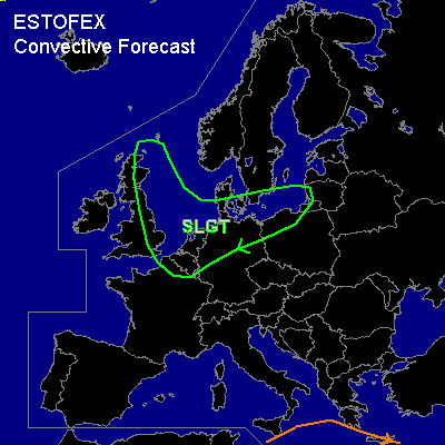

CONVECTIVE FORECAST
VALID 06Z SUN 21/12 - 06Z MON 22/12 2003
ISSUED: 20/12 17:31Z
FORECASTER: GATZEN/GROENEMEIJER
AMENDED
There is a slight risk of severe thunderstorms forecast across north-central Europe
General thunderstorms are forecast across the southern Mediterranean
SYNOPSIS
Between an intense trough over the British Isles and an upper ridge over the Iberian Peninsula, a jet streak is forecast to reach Central Europe tomorrow morning. At lower levels ... strong cyclogenesis has set in over the British Isles and an intense low pressure system is expected over the North Sea at the beginning of the forecast period. Over the eastern part of the Mediterranean ... a trough is expected to form.
DISCUSSION
...Northern Central Europe...
An intense upper short-wave trough is forecats to move eastward over north-central Europe, and intense cyclogenesis is expected over the North Sea during the next hours. Latest WV image shows a well developed dry intrusion indicative of rapid deepening of the low pressure system. The associated cold front is expected over eastern Germany at the beginning of the forecast period. Behind the front ... a well-mixed maritime airmass will enter Benelux, northern France and northern Germany. Within this air-mass, CAPE values in the order of 100 J/kg are forecast by latest model output. Mostly isolated showers with strong gusts are expected. A secondary cold front is expected to move into the northern BeNeLux in the late morning hours and move rapidly eastward reaching eastern germany in the late afternoon hours. Clustered showers and/or rain is expected near this system. The strongest gusts ... of up to 60 kt and possibly somewhat higher locally in coastal areas ... are expected at the passage of or nearby this system.
#