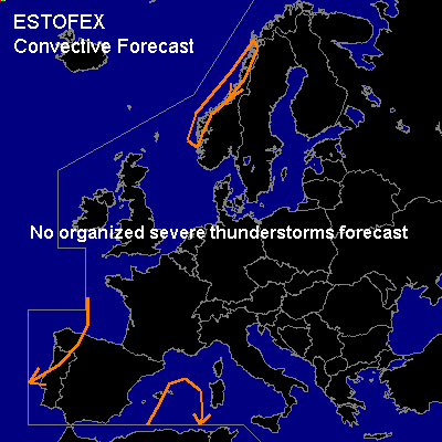

CONVECTIVE FORECAST
VALID 06Z THU 18/12 - 06Z FRI 19/12 2003
ISSUED: 17/12 16:23Z
FORECASTER: GATZEN
General thunderstorms are forecast across western Iberian Peninsula, western Norway, portions of the western Mediterranean
SYNOPSIS
South of the relatively northern polar frontal zone ... upper ridge covers central Europe at the beginning of the forecast period. Over southwestern and eastern Europe ... two amplified troughs are flanking the ridge. At lower levels ... warm airmass spreads northward over western Europe ... while cold airmass will remain over southeastern Europe. Both airmasses do not show good conditions for convection. Over southwestern Europe, latest soundings show a rather strong cap above the boundary layer. Tomorrow ... approaching slightly negatively tilted upper short-wave trough will lead to synoptic-scale upward vertical motion that could reduce the cap. Additionally, cyclogenesis is forecast over the western Mediterranean. West of a cold front that is expected to cross the western Mediterranean during the forecast period, cold airmass should dominate ... Especially over the southwestern portions of the Iberian Peninsula and later over the western Mediterranean model output suggests some CAPE within this airmass. Showers should develop that may produce isolated thunder ... chance should be too low for a gen thunder area, though. Over southeastern Europe ... model output and soundigs indicate a rather stable vertical layering ... thunderstorms are not expected during the forecast period. Over northern Europe ... convectively mixed airmass is expected west of Scandinavia. Orographic lift and strong synoptic forcing could lead to some convection, producing isolated thunder. Due to the strong pressure gradient, severe wind gusts should occur that are not related to organized convection.
DISCUSSION
#