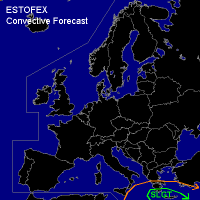

CONVECTIVE FORECAST
VALID 06Z SAT 13/12 - 06Z SUN 14/12 2003
ISSUED: 12/12 17:30Z
FORECASTER: GATZEN
There is a slight risk of severe thunderstorms forecast across Southern Greece
General thunderstorms are forecast across East-central Mediterranean
SYNOPSIS
Well developed westerly jet over northern Europe ... with several short-waves traveling eastward. Intense vort-max south of Iceland on Saturday, 06 UTC will reach Central Europe at the end of the forecast period as Scandinavian trough will amplify into Central Europe. Some thundery showers may form as the cold front reaches Benelux and Germany, where severe wind gusts will be possible. Over the eastern Mediterranean ... cut-off low will move eastward.
DISCUSSION
...East-central Mediterranean
...
Upper cut-off low over the southern Mediterranean will move northeastward. Intense jet streak associated with a strong vort-max over northern Libya on Saturday 12 UTC will rotate around the cut-off reaching Crete in the evening. At the surface ... cold front has crossed Libya and starts moving northeastward, reaching Crete during the forecast periode. Just north of this cold front ... warm and moist low-level airmass originating from the eastern Mediterranean is advected westward as far as southern Italy. Surface observations indicate dewpoints of around 15 Celsius within this airmass ... giving reason to believe that CAPE could reach up to 1000 J/kg. As the cut-off moves northeastward ... DCVA and upper cooling should reduce the cap, and thunderstorms should form along the cold front, where low level airmass should likely reach its LFC. Just north of the cold front, model output suggests moderate easterly surface winds, veering to SSE at 850 hPa over southern Greece and Crete. Thunderstorms should be potentially strong in the case of this moderate vertical shear. In the evening ... synoptic forcing and deep layer shear should increase significantly as the vort-max approaches over Crete ... and thunderstorms may organize into a MCS along the surface front... Severe wind gusts should be the main threat. However ... rotating storms should be possible due to enhanced SRH values and large hail and a few tornadoes, probably as intense as F2, should occur.
#