CONVECTIVE FORECAST
VALID 06Z MON 08/12 - 06Z TUE 09/12 2003
ISSUED: 07/12 20:15Z
FORECASTER: GROENEMEIJER
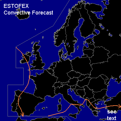
General thunderstorms are forecast across extreme western europe including western Ireland and the western and southern Iberian peninsula as well as parts of the southern Mediterranean Region including southern Italy, southern Albania, southern Greece, and southern Turkey.
SYNOPSIS
At 06Z... a large high-pressure area is forecast over west-central Europe. A vigorous upper trough over eastern Europe continues to move southeastward. A vorticity maximum is cutting off from the trough's southern tip. This results in an upper low filled with cold air becoming stationary over the Tyrrhenean Sea. A cold front is slowly moving southward over the western Mediterranean. Especially near the upper low the fronbtal passage may be accompanied by thunderstorms. The front will become stationary near a developing upper low near Sicily and retreat northward as a warm front over the Ionian Sea. A weak trough is located over the southern Agean Sea and will move slowly northeastward. A trough from the Altantic is rapidly digging southward and will likely affect western Iberia mostly during the second half of the forcast period.
DISCUSSION
...Eastern Agean Sea, southern Turkey...
Deep-layer (0-6 km) shear in the 40-50 kt range and a few 100s of J/kg 50hPA ML CAPE are forecast to remain present east the aforementioned trough over the Aegean Sea. Weak lift ahead of the trough will likely support one or two MCS's or more isolated storms. Conditions are expected to be marginally supportive of supercell storms, so that localised strong winds and large hail may occur.
#