CONVECTIVE FORECAST
VALID 06Z FRI 05/12 - 06Z SAT 06/12 2003
ISSUED: 04/12 21:19Z
FORECASTER: HAKLANDER
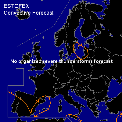
General thunderstorms are forecast across the Baltic Sea, parts of the Iberian Peninsula and the Balearic Sea, Sicily, and the Eastern Mediterranean.
SYNOPSIS
High-over-low pattern across Western Europe makes a slight clockwise tilt between 10-20E. East of the blocking high, an upper trough pushes into NWRN Russia from the north. In between these two systems, a shortwave trough (VORTMAX) travels SEWD across the Baltic Sea along a strong NWLY jet.
DISCUSSION
...Baltic Sea...
GFS12Z calculates marginal MUCAPE (<100 J/kg) which could result in a few thunderstorms, considering the strong upward forcing ahead of and near the VORTMAX and the absence of CIN.
Although deep shear is significant (possibly 50+ kts) in the positive CAPE area, latent instability is considered too small to warrant a SLGT risk. Severe convective wind gusts of 50+ kts are, however, not excluded.
...Iberian Peninsula, Balearic Sea...
Near the quasi-stationary ULL, MUCAPE of generally below 500 J/kg and the presence of latent instability up to 850 hPa (Showalter Index around zero) could result in scattered thunderstorm activity. The largest deep layer shear (50+ knots) will probably remain outside the positive CAPE area, but storms could form in a 40-50 kts deep shear environment, which might be sufficient for one or two convective wind events. However, CAPE appears too low and the situation is too conditional to warrant a SLGT risk.
#