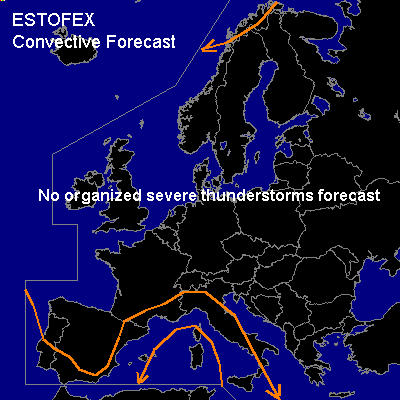

CONVECTIVE FORECAST
VALID 06Z THU 04/12 - 06Z FRI 05/12 2003
ISSUED: 03/12 18:25Z
FORECASTER: GATZEN
General thunderstorms are forecast across parts of western Mediterranean, southern Iberian Peninsula, northern Scandinavia
SYNOPSIS
Long-wave ridge situated over Europe ... with an embedded cut-off low over the Iberian Peninsula moving westward. To the north of this cut-off, a new ridge builds up over the northeastern Atlantic during the forecast period yielding a northwesterly flow over the eastern portions of the forecast region.
DISCUSSION
...Western Mediterranean
...
Mentioned cut-off low will move westward. Along its periphery ... upper jet (about 60 kts at 300 hPa) is forecast over the western Mediterranean, southern France, and northern Iberian Peninsula. Embedded strong vort-max will reach France at the beginning of the forecast period and weakens. At lower levels ... cold front over west-central Mediterranean will separate from the upper trough and will reach western Italy. East of this front ... tongue of moist airmass will remain. This airmass is characterized by a relatively cold boundary layer covered by a moist airmass and steep lapse rates above, yielding elevated CAPE up to 1000 J/kg. Tomorrow ... thunderstorms should continue along the cold front. Weakening forcing far from the upper trough is expected and severe thunderstorms are not likely. However ... if a storm becomes surface-based, severe storms should be possible due to relatively strong vertical wind shear. Overall threat seems to be quite low though.
Underneath the cut-off ... foci of thunderstorms should be the northwestern Mediterranean and the southwestern Iberian Peninsula, as two vort-maxima will cross the affected regions. Over the northwestern Mediterranean ... moderate vertical wind shear is expected, and one ore two thunderstorms may be strong and could produce marginal severe wind gusts. Over southern Iberian Peninsula ... vertical shear should be rather low and severe thunderstorms are not expected.
#