CONVECTIVE FORECAST
VALID 06Z WED 03/12 - 06Z THU 04/12 2003
ISSUED: 03/12 00:57Z
FORECASTER: GROENEMEIJER
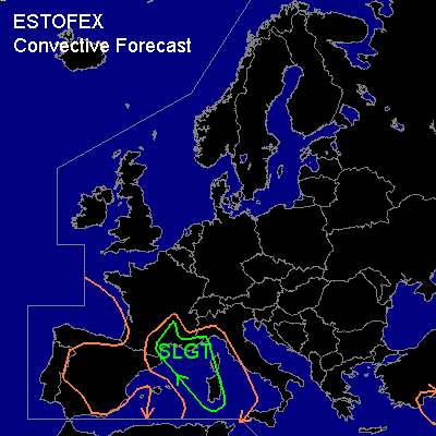
There is a slight risk of severe thunderstorms forecast across parts of southeastern France, Corsica, Sardinia and a part of extreme western Italy.
General thunderstorms are forecast across the Bay of Biscay, western, southern and extreme northeastern Iberia, parts of southern France and northwestern Italy and parts of the western Mediterranean Sea, Corsica and Sardinia as well as southern Turkey and a part of the eastern Mediterranean Sea.
SYNOPSIS
Two mid/upper low pressure systems over northwestern Iberia and northwestern Algeria are merging, during which both transform into troughs wandering around the new center over central Iberia. The Algerian trough is expected to move northward into the western Mediterranean, while inducing surface cyclogenesis ahead of it. East of a ridge over south-central and central Europe, another upper low pressure system is slowly moving southward over central Turkey. A strong zonal polar jet stream is located over northern Europe. An embedded vorticity maximum located near the southern tip of Greenland is forecast to be located jst west of northern Scandinavia at the end of the forecast period.
DISCUSSION
...Southeastern France, western Mediterranean, part of extreme western Italy, Corsica and Sardinia....
Ahead of the trough lifting out of Algeria, an increasingly strong southeasterly flow is expected in the lower half of the troposphere generally east of the Baleares. Latent instability is expected to build east of a developing cold front, roughly near a line from Narbonne southsoutheast ward to just east of the Baleares, as the flow brings higher theta-e air into the region accompanied by strong QG rising motions and cold advection aloft.
Ongoing stratiform precipitation is expected to increase over the northern part of the slgt risk area during the morning, while the chance of embedded storms will increase. As low level wind will increases strongly to 50-70 knots at 850 hPa, low level (0-1 km) shear is expected to become high to extreme reaching values of 30-50 knots. This amount of low-level shear, low LCL heights and a few 100's J/kg of CAPE are thought to be sufficient to produce a few tornadoes associated with (embedded) mini-supercell storms across the slgt risk area. Furthermore, the thunderstorms may be accompanied by strong to very strong wind gusts, possibly in excess of 60 knots near the coast of southeastern France. Biggest problems however will likely be caused by continuing intense rainfall over already saturated soils in southern and southeastern France and the bordering part of Italy. This however falls outside the scope of ESTOFEX outlooks (at this moment, see information section).
#