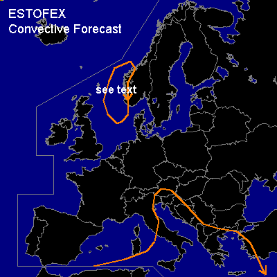

CONVECTIVE FORECAST
VALID 06Z FRI 28/11 - 06Z SAT 29/11 2003
ISSUED: 27/11 16:40Z
FORECASTER: GATZEN
General thunderstorms are forecast across north-central Mediterranean, eastern Mediterranean, southwestern Scandinavia
SYNOPSIS
Between two long-wave ridges over the northeastern Atlantic and eastern Europe amplified trough is present whit an axis extending from Iceland to the western Mediterranean. As new long-wave trough builds up over the northern Atlantic, the western European trough will move slowly northeastward and cuts off over the Alpine region while weakening. At lower levels ... cold airmass situated over France disperses into the western and central Mediterranean where it should stabilize due to cold air advection and anticyclonal differential vorticity advection west of the trough. Thunderstorms are not expected over the affected region. To the northeast, cold airmass will probably destabilize underneath the trough axis over Italy and the Adriatic Sea, where a vort-max is forecast at 12 UTC due to GFS. Showers and thunderstorms should form and spread northeastward. However ... vertical shear will be weak in the range of the trouth axis ... and storm organization seems not to be likely. Over the eastern Mediterranean ... realtively warm airmass is present. Soundings do not indicate steep lapse rates and CAPE values are expected below 200 J/kg. At the end of the forecast period ... cold front should reach Greece, and some showers and thunderstorms are expected along and ahead of this feature. Weak forcing and weak vertical wind shear are forecast and organized convection should not form.
DISCUSSION
...Southwestern Scandinavia...
Over northwestern Europe ... vort-max will cross the North Sea. 12 UTC soundings indicate a moist boundary layer while mid-level airmass is relatively dry with quite steep lapse rates attm. As the vort-max approaches ... showers and thunderstorms are forecast along the southwestern border of Norway moving northeastward. Due to the isobaric gradient, strong gusts are forecast in association with this convection. As low level shear could be quite large due to orographic influence downstream of Scandinavia... organized thunderstorms are also possible that could produce small hail and severe wind gusts. Overall threat is too low to warrant a SLGT RISK.
#