CONVECTIVE FORECAST
VALID 06Z TUE 25/11 - 06Z WED 26/11 2003
ISSUED: 24/11 23:04Z
FORECASTER: HAKLANDER
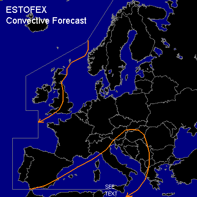
General thunderstorms are forecast across large parts of the British Isles.
General thunderstorms are forecast across the Western Mediterranean, Italy and surrounding waters, and the Northwestern Balkan.
SYNOPSIS
Upper low near Iceland dominates flow pattern across much of NW Europe as a weak upper ridge builds across Finland. At 200 hpa, a strong cyclonic jetstream gradually extends SWD towards the Bay of Biskay before turning NNEWD towards Scandinavia. To the W of the British Isles, an embedded jet streak is associated with a baroclinic zone across that area. Along the Algerian Mediterranean coast, a low pressure system, which is well-defined in the entire troposphere, progresses ENEWD and should reach Sardinia by WED/06Z.
DISCUSSION
...British Isles...
Numerical models suggest strong cyclogenesis to the NW of the British Isles, in association with an unstable wave along the baroclinic zone, near the LER of the aforementioned jet streak. In the polar air mass behind this wave, low MUCAPE of <500 J/kg, possibly increased due to adiabatic cooling aloft, could yield the formation of a few thunderstorms. Although deep vertical wind shear is significant along the cold front (up to 60 kts), it very rapidly decreases in the polar air mass behind it. Furthermore, 0-2 km shear in the low CAPE air mass should remain below 20-25 kts. With this thermodynamic and kinematic setup, severe storms are not expected across the area.
...Southcentral Mediterranean...
Ahead of the cold front of the low pressure system, weak theta-e advection at low levels could produce MUCAPE of 500+ J/kg. Monday's GFS00Z calculated Showalter Index values near zero, suggesting the presence of latent instability well above the surface layer as well. By WED/06Z, a narrow jet streak along the cold front near Sicily could yield deep layer shear of 50+ knots. Conditional on the amount of overlap between the low CAPE and high shear, conditions might become favorable for one or two severe convective wind events near the end of the FCST period. Large hail seems very unlikely due to the low CAPE, but 0-1 km shear of 20-25 kts might yield sufficient low level SREH to produce a brief tornado. The setup is considered too conditional to warrant a SLGT.
#