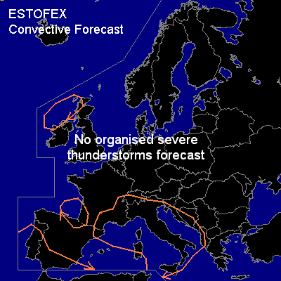

CONVECTIVE FORECAST
VALID 06Z MON 24/11 - 06Z TUE 25/11 2003
ISSUED: 24/11 02:08Z
FORECASTER: GROENEMEIJER
General thunderstorms are forecast across The central and northwestern Mediterranean, southern and southwestern Iberia, northern Iberia and southwestern France as well as the extreme northwestern parts of the British Isles.
SYNOPSIS
An air-mass of polar origin is present near a complex
mid/upper low/trough over southwestern Europe.
Here, scattered thundery showers are ongoing and will likely continue,
in particular over sea-water and near mesoscale
areas of rising motion associated with shortwave
troughs and upstream of mountain ranges.
Warm advection is forecast over and near the Thyrrenean Sea,
southeastern France and western Italy. Especially over the southern
Thyrrenean Sea and southward over Sicily some modest (elevated)
latent instability may build.
A vigorous trough is expected to move eastward over Morrocco and affect
the weather in the central Mediterranean after this forecast period
as it lifts out of the Sahara. Some storms embedded in a mesoscale
precipitation area will likely affect southern Iberia tomorrow. Some more isolated storms may later affect southwestern Iberia.
A stable air-mass is present over northern and eastern Europe so that
thunderstorms are unlikely despite the strong dynamics in place
near a developing cyclone over Finland.
A strong westerly flow is expected to move into extreme
western Europe during the period. The polar air-mass that
will be advected to the northern British Isles may allow for
some thundery showers.
DISCUSSION
...Southeastern France, Thyrrenean Sea,
Italy and the northwestern Balkans....
Ahead of a shortwave trough moving into the area,
some probably elevated thunderstorms will be ongoing over southeastern France
and northwestern Italy while some additional storms may develop further
southward over the Thyrrenean Sea and Sicily. Convective activity will
likely spread over central Italy and possibly affect the Adriatic Sea as well
as the northwestern Balkans. The risk of any severe weather with these
storms will be small because of the elevated nature of the storms
and the small instability.
#