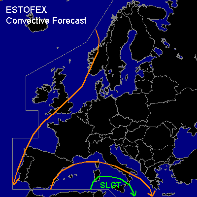

CONVECTIVE FORECAST
VALID 06Z FRI 21/11 - 06Z SAT 22/11 2003
ISSUED: 20/11 23:56Z
FORECASTER: GATZEN
There is a slight risk of severe thunderstorms forecast across southern central Mediterranean
General thunderstorms are forecast across western Mediterranean
General thunderstorms are forecast across western Europe
SYNOPSIS
Broad upper ridge extending over Europe. Embedded cut-off low over the western Mediterranean digging NE-ward. Over the NE-ern Atlantic ... upper trough will expand SE-ward, and the SW-ern flow should involve the cut-off low over the western Mediterranean.
DISCUSSION
...Mediterranean
...
NE of the cut-off low ... SE-erly flow is present over the western Mediterranean, and warm airmass originating from the Atlas mountains is advected NW-wards. This airmass is characterized by steep lapse rates between 900 and 770 hPa as indicated by todays LIEE Cagliari Sounding. Underneath the capping inversion ... boundary layer moisture has recovered yielding CAPE values in the order of 1000 J/kg. During the forecast period ... showers and thunderstorms are expected in the range of the cut-off low. The activity should deflect E-ward as the upper trough will propagate NE-wards and WAA should decrease over the western Mediterranean. Synoptical forcing should be relatively weak, and thunderstorms should be rather isolated. Also weak deep layer shear underneath the cut-off low does not support organized convection over the western Mediterranean. However ... Over the southern central Mediterranean ... latest model output suggests CAPE up to 2000 J/kg tomorrow evening, and BOLAM suggests that a jetstreak could reach the southern Mediterranean, where UVM is forecast. As deep layer wind shear should increase during the day ... some thunderstorms could organize and multicells/ embedded supercells are expected. Large hail, severe wind gusts and one or two tornadoes are forecast.
...Western Europe
...
Underneath the through axis of the NE-ern Atlantic trough ... cold airmass will spread southwards during the forecast period. Latest model output suggests some CAPE due to relatively warm SST. However ... strong showers and thunderstorms are not expected as instability should be restricted to the lowest kilometers just west of the cold front.
#