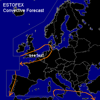

CONVECTIVE FORECAST
VALID 06Z FRI 14/11 - 06Z SAT 15/11 2003
ISSUED: 13/11 21:04Z
FORECASTER: GATZEN
General thunderstorms are forecast across SEern central Mediterranean
General thunderstorms are forecast across NWern Europe
General thunderstorms are forecast across Western Iberian Peninsula
SYNOPSIS
Blocking ridge over northern Europe dissipates. South of this feature, weak upper long-wave trough will remain over central and western Mediterranean. Over NWern Europe ... long-wave trough is expected to expand into western and SWern Europe. Several vort-maxima are traveling around its edge that affect NWern and SWern Europe during the forecast periode.
DISCUSSION
...SEern central Mediterranean...
Short-wave trough embedded in the southern European long-wave trough will move eastward. Downstream, a deep SWerly flow is present and air originating from the Sahara is advected into SEern central Mediterranean. Rawinsonde data show some mixed layers over northern Africa, and GFS model output suggests that CAPE could reach several 100s J/kg south of Italy and Greece, where a relatively moist boundary layer is present. In the range of the long-wave trough ... CIN should be weak and DPVA should lead to some synoptic-scale UVM as CAA is forecast to be weak. During the forecast periode ... thunderstorms should go on over SEern central Mediterranean and spread eastward. As vertical shear will be quite low, organized thunderstorms seems to be not likely.
...NWern Europe...
Within the delta of the eastern Atlantic flow regime a strong cyclone has formed over the British Isles. During the forecast periode ... this intense surface low should weaken while slowly moving NEward. The back-end occlusion should reach the British Isles with stratiform rain. To the south of this occlusion ... a convectively mixed airmass is expected that spreads eastward. During the forecast periode ... a relatively strong vort-max extending from the southern British Isles to northern France propagates eastward. It is expected over northern Germany by the end of the forecast periode. In association with this vort-max ... some showers/thunderstorms should develop within the convectively mixed airmass. This showers/thunderstorms are forecast to reach northern Germany at the end of the periode. Strong vertical wind shear could possibly lead to some storm organization, and severe wind gusts connected to bow shaped segments are not ruled out ATTM. However ... convective activity should be too low to warrant a SLGT RISK.
#