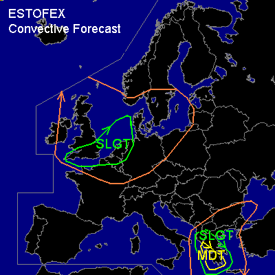

CONVECTIVE FORECAST
VALID 06Z MON 03/11 - 06Z TUE 04/11 2003
ISSUED: 03/11 01:54Z
+ + + AMENDED + + +
FORECASTER: GROENEMEIJER
There is a moderate risk of severe thunderstorms forecast across southern and western portions of the Greek mainland.
There is a slight risk of severe thunderstorms forecast across much of the southwestern Balkans, western and central Greece.
There is a slight risk of severe thunderstorms forecast across Southeastern Britain, The Low Countries, extreme northwestern France.
General thunderstorms are forecast across The British Isles, the lower Rhine plains, northern Poland and southern Scandinavia.
General thunderstorms are forecast across the southern Balkans and Greece
SYNOPSIS
At the beginning of the forecast period a large mid/upper trough will be located over western Europe. A polar air-mass is advected into west-central and northwestern Europe. A small mid/upper low-is separating from a trough over the western Balkans. The resulting low south of Italy is expected to move slowly eastward.
DISCUSSION
...Southern Balkans...
Ahead of a cold front approaching the Greek west coast, a very warm air-mass is advected northward. A strong capping inversion is in place well into the warm air-mass as is shown by the Athens (LGAT), Heraklion (LGIR) and Thessaloniki (LGTS) soundings. However, rising motions ahead of the front and advection of colder air from the west should be able to get rid of the inversion just before the front. Numerical models (GFS/MM5) develop an area of convective precipitation affecting much of southwestern Greece, Albania and the F.Y.R. of Macedonia on Monday.
Over the moderate risk area...strong deep-layer shear (~50 kt 0-6 km) and low-level winds veering with height are expected to allow supercells to form, that will likely be accompanied by large hail and strong winds. Some threat for tornadoes will exist as well.
To the northeast of the MDT risk area, shear will be somewhat weaker, but organised convection will be possible in this area later on Monday as the frontal zone approaches. Some isolated severe weather events are possible throughout the SLGT risk area.
Apart from winds, hail and tornadoes, very high rainfall amounts are possible locally over western Greece.
...Southeastern Britain, the Low Countries, extreme northwestern France....
Thunderstorms have formed in an unstable polar air-mass advecting into western Europe. Most instability will likely be located over the southern half of the British Isles, the North Sea and the Low Countries. In fact the Monday/00Z sounding from Herstmonceux (03882) in southern Britain measures approximately 350 J/kg MLCAPE50.
One or two surface troughs will likely move eastward over southern Britain and the Channel region and later affectLow Countries. Strong (30 kt 0-1 kt) low-level shear will help to organise the storms into linear modes and mini-supercells / embedded mesocyclones. Strong wind gusts exceeding 50 knots in a few places. There will also be a small threat of tornadoes and large hail near embdded mesocyclones.
#