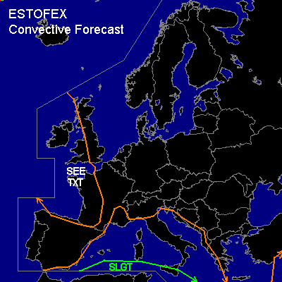

CONVECTIVE FORECAST
VALID 06Z THU 30/10 - 06Z FRI 31/10 2003
ISSUED: 29/10 20:51Z
FORECASTER: HUGO
There is a slight risk of severe thunderstorms forecast across SOUTHERN GREECE & CYPRUS
General thunderstorms are forecast across SOUTHERN IRELAND, SOUTHWEST ENGLAND & WALES, W=ERN FRANCE, N=ERN SPAIN & PORTUGAL
General thunderstorms are forecast across ITALY, SCILIY, SARDINIA, CORSICA & A LARGE PART OF SE=ERN EUROPE
SYNOPSIS
Long wave trough dominating over Northwest Europe in association with a 180KT-190KT meridional jet digging Southwards into parts of France & Spain during the discussion period...A deepening surface low pressure will be effecting the UK and parts of France & Spain in association with the upper level jet...Minor short-wave troughs will move through the long wave pattern with a noticeable vorticity max moving Eastwards through Italy during the discussion period...100KT subtropical jet pushing through the Eastern Med during the discussion period...Only parts of Western Russia will be effected by high pressure with the majority of Europe being dominated by a cyclonic pattern...
DISCUSSION
...SLGT RISK...
A minor surface frontal feature will be effecting the SLGT risk region during the course of the discussion period with a surface cold front under-going a period of frontogenesis...Significant WAA (theta-w >18C) within the SLGT risk region coupled with a minor vorticity max will allow convective activity to occur...Forecast soundings show a highly unstable atmosphere with lowest 30hPa MLCAPE values generally in excess of 1000j/kg with SBCAPE values as high 2000j/kg...The upper level 100KT jet moving through the region will aid a significant amount of deep layer shear, with 0-6KM values generally in excess of 40 to 50KT coupled with low level shear (0-1KM) in excess of 15 to 20KT, this will bring the risk of multicell development...However with 0-3KM helicity values in excess of 125m2/s2 there is slight to moderate risk of supercell development bringing a risk of one or two tornadoes/water spouts, large hail and some damaging windgusts from any of the more intense convective activity...The main convection may become allinged just ahead of the developing cold front just to the Northwest of Cyprus by 310000z later on in the day...
...ITALY, SARDINIA, CORSICA, SCILIY, PARTS OF SE EUROPE...
Scattered convective activity is possible anywhere within the SEE TXT region during the discussion period...The cyclonic upper level pattern in association with the long wave trough will create a limited convectively responsive atmosphere...A short-wave trough moving through the long wave pattern in association with a vorticity max may bring a focal point for convective activity into parts of Eastern Italy during tomorrow afternoon before moving into parts of Croatia and Bosnia Hercegovina...Forecast soundings show lowest 30hPa MLCAPE values to be no greater than around 500j/kg and SBCAPE values will struggle to reach 1000j/kg...Convection is likely to remain below severe limits but with some reasonable deep layer shear (0-6KM) >40KT scattered throughout the region along with some highly favourable low level shear (0-1KM >25KT) there is scope for one or two multicell storms bringing some moderate sized hail and some limited strong wind gusts...Any convection is likely to disperse during the evening period...
...SOUTHERN IRELAND, SOUTHWEST ENGLAND, W=ERN FRANCE, N=ERN SPAIN & PORTUGAL...
Convective activity within the above mentioned regions will mainly arise from the highly active atmospheric conditions in association with long wave trough, intense upper level jet and mainly within the polar airmass behind the main frontal features of the surface low pressure...CAA in association with the change to a returning polar maritime airmass coupled with warm sea temperatures will spawn widespread convective activity behind the main frontal features and this will be blown into coastal regions of Ireland, Southwest England (possible later Central/Southern England), Western France, Northern Spain & Portugal during the course of the discussion period...Deep layer and low level shear especially will be approaching intense values in association with the upper level jet...Low level shear (0-1KM) over parts of Northern Spain may reach values in excess of 40KT couple this with deep layer shear (0-6KM) in excess of 40 to 50KT in places there is reasonable scope for multicell development...While convective activity for the most part is likely to remain below severe limits some very strong wind gusts in association with the strong West to Northwesterly flow and convective activity is possible, especially again around coastal regions of Western France, Northern Spain & Portugal within the SEE TXT region, some gusts may reach 50 to 55KT . Southern Ireland & Southwest England will be at a lower risk because the low pressure will be located over this region so winds are likely to remain light throughout the discussion period (more especially after 301200z), but some convective gusts may reach 35 to 40KT...With favourable WBZ heights in association with the polar airmass some moderate sized hail is also possible...Convective activity maywell persist into the overnight period in association with a constant feed of warm low level sea temperatures and the upper level CAA...An update maybe needed during the course of tomorrow if convective activity becomes more widespread or organised as surface troughs are possible and if this is the case then convective activity maywell reach severe limits on a more widespread scale...
#