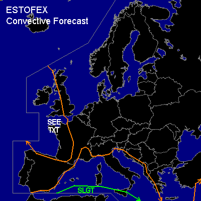

CONVECTIVE FORECAST
VALID 06Z WED 29/10 - 06Z THU 30/10 2003
ISSUED: 28/10 13:10Z
FORECASTER: HAVEN
There is a slight risk of severe thunderstorms forecast across the southwestern Mediterranean Sea
General thunderstorms are forecast across the western and central Mediterranean Sea, Italy, the Adriatic Sea and surrounding coastal areas
General thunderstorms are forecast across the western British Isles, western France and the Bay of Biscay
SYNOPSIS
Strong /up to 150 kts at 300 hPa/ w-nw jetstream w-sw of the British Isles will point towards the Bay of Biscay in the course of the day and will affect France later. Sfc coldfront, wednesday is progged at 06Z from London to Brest and will move southeast and cross France during the period.
Another, zonal, branch of the jetstream is located further south over the Mediterranean Sea. An upper trough over the Iberian Peninsula will progress eastward of the western Mediterranean Sea.
DISCUSSION
...southwestern Mediterranean Sea
...
Scattered tstms fcst invof low level trough... which is moving west and should remain oriented ne-sw across wrn Mediterranean sea. Greatest convective and severe probabilities will be over the southern portions of the western Mediterranean where 35-40 kt shear vectors will be in place along with 250-500 J/kg MLCAPE. A few supercells or small bows may develop near the low level trough with damaging gusts and a tornado possible.
...western France...
Nearly unidirectional vertical wind profiles are fcst later in the afternoon and evening with generally 45-55 kt 0-6 km shear. Low-topped lines and/or bowing line segments of tstms are expected along/behind of cold front... as it advances into marginally unstable air mass. Damaging wind is main threat. Strongest downdrafts from fast-moving cells may reach sfc with damaging intensity. Lack of significant instability will limit coverage/intensity of damaging wind potential.
#